23rd November 2020 Update @ 5.30 pm IST
Depression Over Southwest Bay of Bengal – Cyclone Alert For Tamilnadu and Puducherry Coasts
દક્ષિણ પશ્ચિમ બંગાળ ની ડિપ્રેસન – તામિલનાડુ એન્ડ પુડુચેરી કોસ્ટ માટે સાયક્લોન અલર્ટ
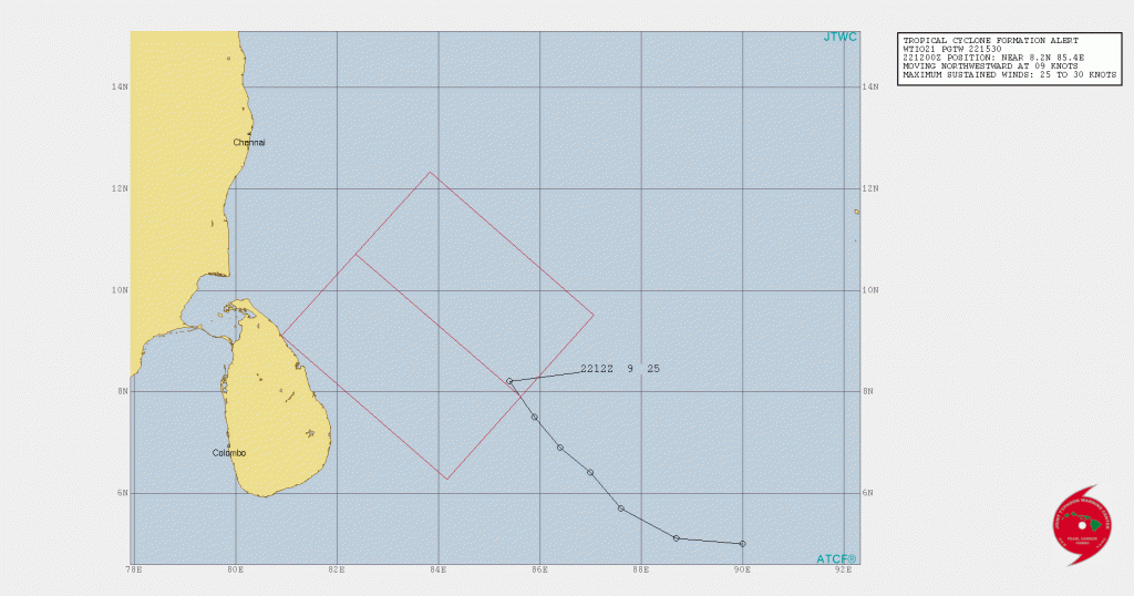
JTWC Tropical Cyclone Formation Alert 22nd November June 1530 UTC ( 09.00 pm. IST)
FROM: INDIA METEOROLOGICAL DEPARTMENT
BULLETIN NO.: 12(ARB/04/2020) and 04(BOB/04/2020)
TIME OF ISSUE: 1530 HOURS IST DATED: 23.11.2020
IMD બુલેટિન નંબર 12(ARB/04/2020) and 04(BOB/04/2020): 1530 કલાક IST તારીખ 23-11-2020 મુજબ
indian_1606129801
Brief Update:
The Depression over southwest and adjoining southeast Bay of Bengal moved West Northwestwards and lay centered at 01.00 pm. IST of 23rd November, 2020 over the same region near latitude 9.8°N and longitude 83.8°E, about 500 km East Southeast of Puducherry and 540 km Southeast of Chennai. It is very likely to intensify into a cyclonic storm during next 24 hours. It is very likely to move towards Tamil Nadu and Puducherry coasts for next two days.
Cyclonic Storm “GATI” weakened into Deep Depression over Somalia
UW CIMMS IR Enhanced Satellite Image of 97B.INVEST ( IMD Depression)
Dated 23-11-2020 @ 1000 UTC ( 03.30 pm. IST)

North India:
Due to active Western Disturbance, there will be Rainfall over parts of North India and snowfall over Hilly regions till 25th/26th November.
Saurashtra Gujarat & Kutch :
Cold weather has prevailed for last three four days. The Minimum Temperature at most places was below normal.
This morning the Minimum Temperature at various locations was as under:
Ahmedabad 13.0 C about 2 C below normal
Gandhinagar 13.3 C
Rajkot 12.4 C about 4 C below normal
Keshod 12.4 C also about 4 C below normal
Kandla (A) 12.6 C Amreli 12.8 about 2 C below normal
Forecast From 23rd to 30th November 2020
The Minimum Temperature will remain below normal at many places tomorrow. Subsequently, the Minimum Temperature will increase at most places and will move towards normal and remain near normal with some places above normal on few days. Later part of the forecast period will see marginal decline in Minimum Temperature.
Caution: Please refer/rely on IMD/RSMC Bulletins/Advisories for Storms & Weather related matter.
સાવચેતી: સ્ટોર્મ કે હવામાન અંગે ની માહિતી માટે ભારતીય હવામાન ખાતા/ગવર્મેન્ટ ના બુલેટીન/સુચના પર નિર્ભર રહેવું.
Click the links below. Page will open in new window
Read Forecast In Akila Daily Dated 23rd November 2020
Read Comment Policy– કમેન્ટ માટે માર્ગદર્શન
ઉપર ની બધી અલગ લિન્ક ક્લિક કરો. નવી વિન્ડો માં પેજ ખૂલશે