23rd June 2020
Current Position of Advance of Southwest Monsoon Over India
દક્ષિણ પશ્ચિમ ચોમાસા નો ઇન્ડિયા માં અત્યાર સુધી ની પ્રગતિ નો નકશો
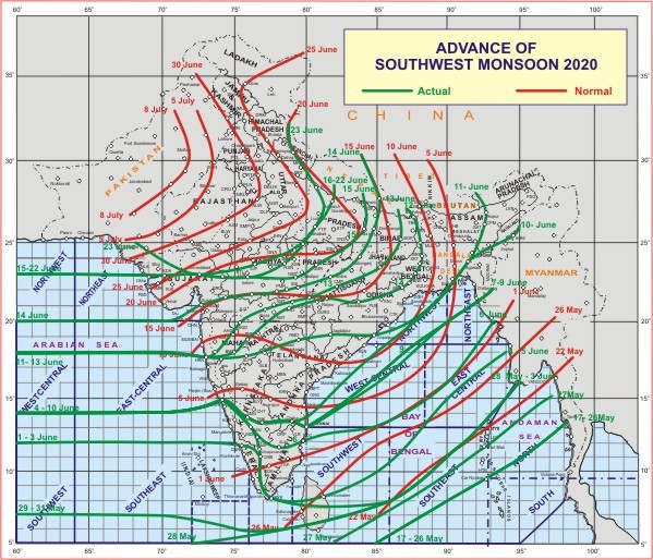
સૌથી ઉપર ની લીલી લીટી ના છેડે જે તારીખ હોઈ તે તારીખે લીટી ની નીચે ના ભાગ માં બધે ચોમાસું પોંચી ગયું છે તેમ સમજવું.
લાલ લીટી જે તે વિસ્તાર માં નોર્મલ ચોમાસું બેસવાની તારીખ દર્શાવે છે
The date shown at the end of green line shows that the Southwest Monsoon has set in over areas below the green line on that date.
Saurashtra, Kutch & Gujarat Has To Wait For Widespread Rainfall – Monsoon To Advance Over Most Parts Of India Except Parts Of Northwest India By 25th June
સાર્વત્રિક વરસાદ માટે સૌરાષ્ટ્ર ગુજરાત અને કચ્છ ને રાહ જોવી પડશે – ચોમાસુ 25 જૂન સુધી માં ઇન્ડિયા ના મોટા ભાગો માં બેસી જશે નોર્થવેસ્ટ ઇન્ડિયા ના અમુક ભાગો શિવાય
Current Weather Conditions:
Few observations from IMD and other weather parameters:
Southwest Monsoon has further advanced into remaining parts of north Arabian Sea, most parts of Kutch, some more parts of Gujarat region, Madhya Pradesh and Uttar Pradesh and some parts of Uttarakhand.
The Northern Limit of Monsoon (NLM) now passes through Lat. 25°N/Long. 68°E, Ahmedabad, Shajapur, Fatehpur, Lat. 29°N/Long. 80°E, Rudraprayag and Lat. 32°N/Long. 79°E.
Conditions are becoming favorable for further advance of Southwest Monsoon into remaining parts of Gujarat, Madhya Pradesh, Uttar Pradesh, entire Western Himalayan Region, Haryana, Chandigarh & Delhi, most parts of Punjab and some parts of Rajasthan during next 48 hours.
The Cyclonic Circulation lies over interior Odisha and neighborhood between 1.5 km & 5.8 km above mean sea level tilting Southwestwards with height.
The trough at mean sea level from Northwest Rajasthan to Northwest Bay of Bengal across Northeast Rajasthan, North Madhya Pradesh, Northern parts of Chhattisgarh, Southern parts of Jharkhand and Northern parts of Odisha and extends up to 1.5 km above mean sea level.
There is a Cyclonic Circulation over Northeast Arabian Sea, the Northeast part of UAC which was near Saurashtra/Kutch at 3.1 km above mean sea level has tracked Westwards.
Click the link below. Page will open in new window. IMD 700 hPa charts shows UAC moved away from Saurashtra/Kutch and another UAC over Interior Odisha.
IMD 700 hPa Chart for 11.30 am. of 23rd June 2020
ઉપર ની લિન્ક ક્લિક કરો. નવી વિન્ડો માં પેજ ખૂલશે. IMD 700 hPa ના વિન્ડ ચાર્ટ આપેલ છે તેમાં યુએસી સૌરાષ્ટ્ર/કચ્છ થી દૂર સર્કેલ છે તેમજ ઇન્ટેરિયર ઓડિશા પર બીજું યુએસી છે.
Forecast: Saurashtra, Gujarat & Kutch for 23rd to 30th June 2020
As per IMD the Southwest Monsoon is expected over most parts of North India, except some parts of Northwest India and also remaining parts of Gujarat by 25th June.
There are no major Low Pressure, UAC that would benefit and Humidity is expected to reduce in 3.1 km level. Hence widespread rainfall is not expected.
70% of Saurashtra, Gujarat & Kutch: Possibility Scattered showers /Light rain on some days at different locations with isolated medium rain.
30% of Saurashtra, Gujarat & Kutch: Possibility Scattered showers /Light/Medium rain on some days at different locations with isolated heavy rain.
Areas that could benefit are Coastal Saurashtra, Gujarat Rajasthan boder areas and Gujarat M.P. border areas.
Conditions expected to improve last days of forecast period.
Caution: Please refer/rely on IMD/RSMC Bulletins/Advisories for Storms & Weather related matter.
સાવચેતી: સ્ટોર્મ કે હવામાન અંગે ની માહિતી માટે ભારતીય હવામાન ખાતા/ગવર્મેન્ટ ના બુલેટીન/સુચના પર નિર્ભર રહેવું.
Click the links below. Page will open in new window
Read Forecast In Akila Daily Dated 23rd June 2020
Read Forecast In Sanj Samachar Daily Dated 23rd June 2020
Read Comment Policy– કમેન્ટ માટે માર્ગદર્શન
ઉપર ની બધી અલગ લિન્ક ક્લિક કરો. નવી વિન્ડો માં પેજ ખૂલશે