Current Weather Conditions on 19th July 2019
Southwest Monsoon has advanced over remaining parts of Rajsthan, thereby covering the entire Country on 19th July 2019 – Conditions expected to improve over Saurashtra, Gujarat & Kutch
દક્ષિણ પશ્ચિમ ચોમાસુ રાજસ્થાન ના બાકી ના ભાગો ને આવરી લેતા સમગ્ર દેશ માં આજે 19 જુલાઈ 2019 બેસી ગયું.
સૌરાષ્ટ્ર ગુજરાત અને કચ્છ માં વાતાવરણ માં સુધારો થશે.
Some weather features from IMD :
The Southwest Monsoon has further advanced into remaining parts of West Rajasthan and thus has covered the entire country today, the 19th July, 2019.
The Monsoon Trough at mean sea level passes through Ganganagar, Hissar, Agra, Banda, Sidhi, Daltonganj, Bhubaneshwar, then southeastwards towards Northwest Bay of Bengal.
The cyclonic circulation over Central Pakistan & adjoining West Rajasthan now lies over Central Pakistan & adjoining Punjab and extends up to 0.9 km above mean sea level.
The feeble off-shore trough at mean sea level from South Maharashtra coast to Karnataka coast now runs from Karnataka to Kerala coast.
A cyclonic circulation lies over Eastcentral Arabian Sea off Maharashtra coast between 3.1 & 3.6 km above mean sea level.
The cyclonic circulation over Northwest Bay of Bengal & adjoining Westcentral Bay of Bengal and south Odisha coast now lies over Westcentral and adjoining Northwest Bay of Bengal & North Andhra Pradesh – South Odisha coasts and extends up to 5.8 km above mean sea level tilting Southwestwards with height.
IMD Advance Of Southwest Monsoon Map.
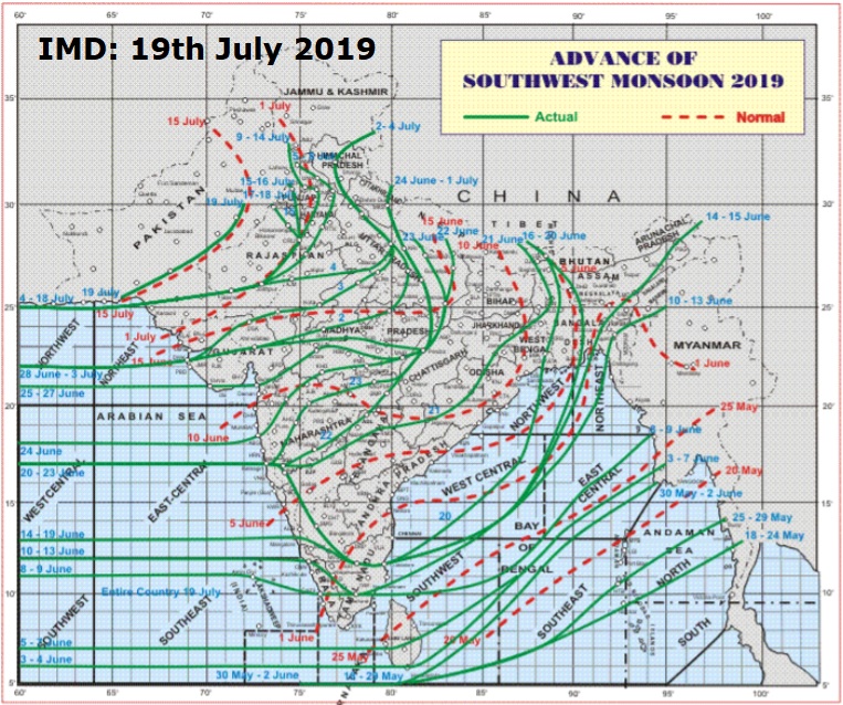
સૌથી ઉપર ની લીલી લીટી ના છેડે જે તારીખ હોઈ તે તારીખે લીટી ની નીચે ના ભાગ માં બધે ચોમાસું પોંચી ગયું છે તેમ સમજવું. 19 જુલાઈ 2019 ના સમગ્ર દેશમાં ચોમાસુ બેસી ગયું છે.
લાલ ત્રુટક લીટી જે તે વિસ્તાર માં નોર્મલ ચોમાસું બેસવાની તારીખ દર્શાવે છે
The date shown at the end of green line shows that the Southwest Monsoon has set in over areas below the green line on that date. Monsoon has set in over whole country on 19th July 2019.
The red dashed line shows the normal date of onset of Southwest Monsoon over various regions
Saurashtra, Gujarat & Kutch: Current conditions
No meaningful rainfall over Saurashtra, Kutch & Gujarat during last one week. There is a shortfall of 64% rain till 18th July 2019 for Saurashtra & Kutch Region, while Gujarat Region has 31% Deficit till 18th July 2019. Kutch is a 90% shortfall from normal till 18th July 2019.
Forecast: 19th July to 25th July 2019
Note: I do not Forecast more than a week ( Referred to as Hu LGAKN in the blog comments)
Cloudy weather on most days except one or two days. Wind speeds of 10 to 25 km during the forecast period.
Gujarat could receive scattered Light/Medium Rainfall with Isolated heavy rainfall on some days of the forecast period. More chances during 20th-23rd July.
Saurashtra & Kutch could receive scattered Showers/Light/Medium Rainfall few days of forecast period during 20th-23rd (more chances on 21/22nd). Again weather would improve on 25th July 2019.
Advance Indication: 26th to 31st July 2019
After the completion of current Bay of Bengal System, there is a possibility of a fresh UAC over Bay of Bengal. This would become a Low Pressure on land. During that period, the Western end of Monsoon is expected to slide downwards to South Rajasthan. Due to this scenario, Saurashtra, Kutch & Gujarat could receive a round of Rainfall. ECMWF is confident about the outcome, however, GFS is differing. Some other International models outcome is concurring with ECMWF.
સૌરાષ્ટ્ર, ગુજરાત અને કચ્છ: તારીખ 19 જુલાઈ થી 25 જુલાઈ 2019
દક્ષિણ પશ્ચિમ ચોમાસુ રાજસ્થાન ના બાકી ના ભાગો ને આવરી લેતા સમગ્ર દેશ માં આજે 19 જુલાઈ 2019 બેસી ગયું.
સી લેવલ માં ચોમાસુ ધરી ગંગાનગર, હિસાર, આગ્રા, બંદા, સીધી, દલોતગંજ , ભૂબનેશ્વર અને ત્યાંથી નોર્થવેસ્ટ બંગાળ ની ખાડી તરફ લંબાય છે.
5.8 કિમિ ના લેવલ નું એક અપાર એર સાયક્લોનિક સર્ક્યુલેશન મધ્ય પશ્ચિમ અને લાગુ નોર્થવેસ્ટ બંગાળ ની ખાડી માં નોર્થ આંધ્ર અને સાઉથ ઓડિશા કિનારા નજીક છે.
મહારાષ્ટ્ર ના કિનારા બહાર મધ્ય પૂર્વ અરબી સમુદ્ર માં એક 3.1 કિમિ નું એક અપર એર સાયક્લોનિક સર્ક્યુલેશન છે.
5.8 કિમિ ના લેવલ માં એક બહોળું સર્ક્યુલેશન દક્ષિણ ભારત, લાગુ અરબી સમુદ્ર પર છે.
એક નબળો ઓફશોર ટ્રફ કર્નાટક થી કેરળ ના દરિયા કિનારા નજીક છે.
સૌરાષ્ટ્ર કચ્છ વિસ્તાર માં 18 જુલાઈ સુધી માં વરસાદ ની 64% ની ઘટ રહી છે જયારે ગુજરાત વિસ્તાર માં 31% ઘટ રહી છે.
આગાહી: 19 જુલાઈ થી 25 જુલાઈ 2019
નોંધ: હું એક અઠવાડિયા થી વધુ ની આગાહી કરતો નથી. Hu LGAKN એટલે હું લાંબા ગાળા ની આગાહી કરતો નથી !
એકાદ બે દિવસ બાદ કરતા, વાદળછાયું વાતાવરણ તેમજ પવન 10 થી 25 કિમિ ની ઝડપ સુધી ફૂંકાય આગાહી ના દિવસો માં.
દક્ષિણ ગુજરાત માં છુટા છવાયા ઝાપટા હળવો/ મધ્યમ વરસાદ ની શક્યતા અને ક્યાંક ક્યાંક ભારે આગાહી સમય ના અમુક દિવસો, ખાસ 20 થી 23 દરમિયાન.
સૌરાષ્ટ્ર અને કચ્છ: છુટા છવાયા વિસ્તારમાં ઝાપટા/હળવો/મધ્યમ વરસાદ 20 થી 23 માં જેમાં વધુ શક્યતા 21/22 ના. તારીખ 25 ના ફરી વાતાવરણ સુધરે તેવી શક્યતા.
આગોતરું એંધાણ: 26 થી 31 જુલાઈ 2019
હાલ ની બંગાળ ની ખાડી ની સિસ્ટમ બાદ ફરી બંગાળ ની ખાડી બાજુ એક યુએસી થશે જે જમીન પર આવ્યા બાદ લો પ્રેસર થશે. સિસ્ટમ આગળ ચાલે ત્યારે ચોમાસુ ધરી નો પશ્ચિમ છેડો તે સમય માં દક્ષિણ રાજસ્થાન સુધી સરકી આવશે જેથી સૌરાષ્ટ્ર, ગુજરાત અને કચ્છ ને વરસાદ નો એક રાઉન્ડ માટે ઉજળી તક છે. ECMWF મોડલ મુજબ નું તારણ છે. બીજા ઇન્ટરનૅશનલ મોડલ પણ ECMWF સાથે સહમત છે પણ હજુ GFS સહમત નથી
Caution: Please refer/rely on IMD/RSMC Bulletins/Advisories for Storms & Weather related matter.
સાવચેતી:
સ્ટોર્મ કે હવામાન અંગે ની માહિતી માટે ભારતીય હવામાન ખાતા/ગવર્મેન્ટ ના બુલેટીન/સુચના પર નિર્ભર રહેવું.