11th June 2019 @ 10.00 am Update
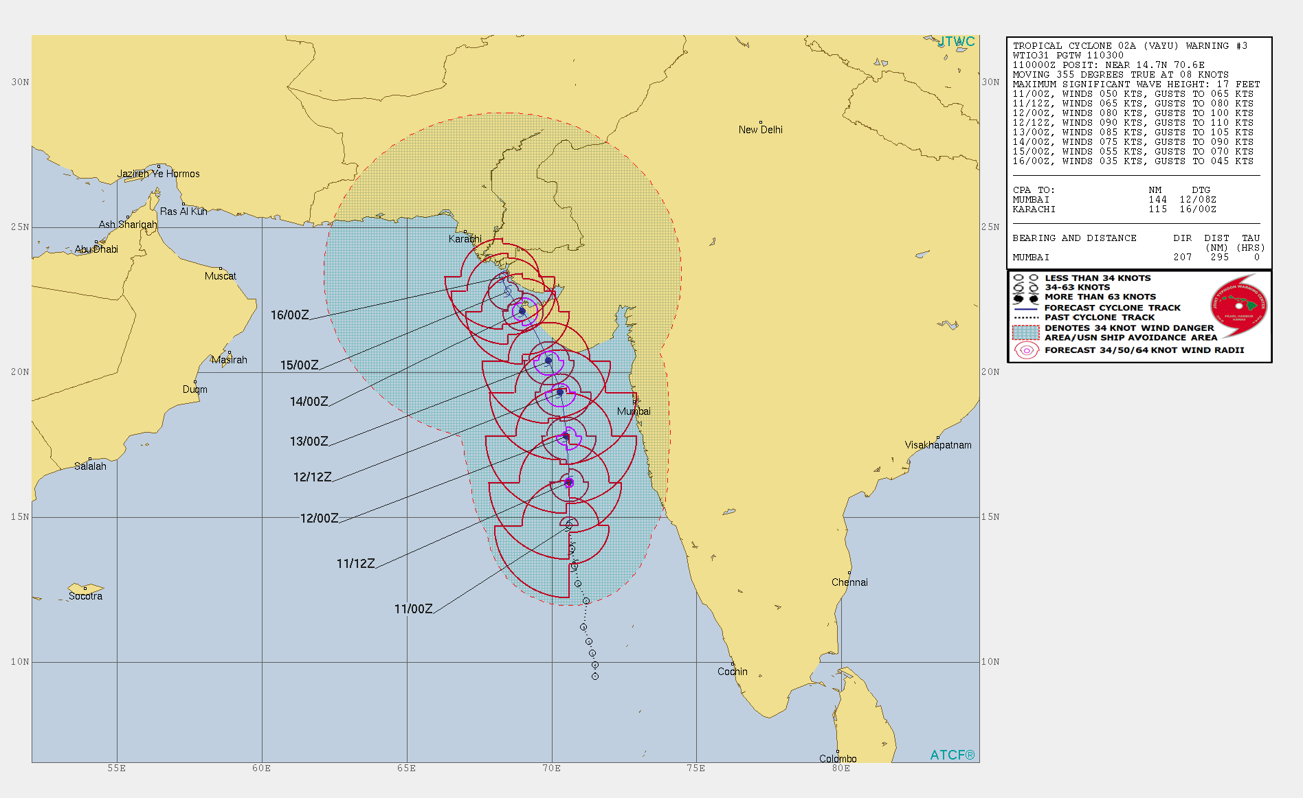
The Deep Depression over Eastcentral & Adjoining Southeast Arabian Sea intensified overnight to a Cyclonic Storm “VAYU” at 1800 UTC on 10th June 2019. JTWC has now issued Tropical Cyclone Warning No. 3 at 0300 UTC on 11th June 2019. The wind speed on International scales is 50 knots ( 90 kms/hour on 1 minute average wind speeds basis. IMD has a 3 minutes average basis). The Central pressure reported is 988 millibars. Location of the System is Lat. 14.7N & Long. 70.6E at 05.30 am IST on 11th June 2019. The System is 650 km. South of Veraval Coast of Saurashtra, Gujarat.
મધ્ય પૂર્વ અરબી સમુદ્ર અને લાગુ દક્ષિણ પૂર્વ અરબી સમુદ્ર માં જે દીપ ડિપ્રેસન હતું તે ગત રાત્રી ના “વાયુ” નામ ના વાવાઝોડા માં પરિવર્તિત થયું છે અને મધ્ય પૂર્વ અરબી સમુદ્ર માં આગળ વધે છે. JTWC મુજબ આજે સવારે 0.530 વાગ્યે લોકેશન Lat. 14.7N અને Long. 70.6E પર કેન્દ્રિત છે. 988 મિલીબાર પ્રેસર છે અને પવનો 50 નોટ ના છે. (90 કિમિ/કલાક 1 મિનિટ ની શરેરાશ મુજબ. IMD પવન ની સ્પીડ 3 મિનિટ ની શરેરાશ પ્રમાણે કહે છે) . આ વાવાઝોડું આજે સવારે 0.530 વાગ્યે સૌરાષ્ટ્ર ના વેરાવળ થી 650 કિમિ દક્ષિણે છે.
IMD BULLETIN NO. : 07 (ARB/01/2019)
TIME OF ISSUE: 0830 HOURS IST DATED: 11.06.2019
Form the Above Bulletin No. 7
It is very likely to move nearly northward and cross Gujarat coast between Porbandar and Mahuva around Veraval & Diu region as a Severe Cyclonic Storm with wind speed 110-120 kmph gusting to 135 kmph during early morning of 13th June 2019.
IMD ના બુલેટિન નંબર 7 મુજબ સારાંશ: આ વાવાઝોડું મુખ્યત્વે ઉત્તર દિશા માં ચાલશે અને 13 જૂન વહેલી સવારે પોરબંદર અને મહુવા ની વચ્ચે વેરાવળ દીવ આસપાસ તીવ્ર વાવાઝોડા તરીકે ક્રોસ કરશે 110-120 કિમિ ની ઝડપે અને ઝટકા ના પવનો 135 કિમિ ની સ્પીડ હોય.
JTWC Tropical Cyclone 02A.VAYU Warning No. 3
Dated 11th June 2019 @ 0300 UTC (08.30 am IST)
| UW-CIMSS Automated Satellite-Based Advanced Dvorak Technique (ADT) Version 9.0 |
|||||
|
|||||
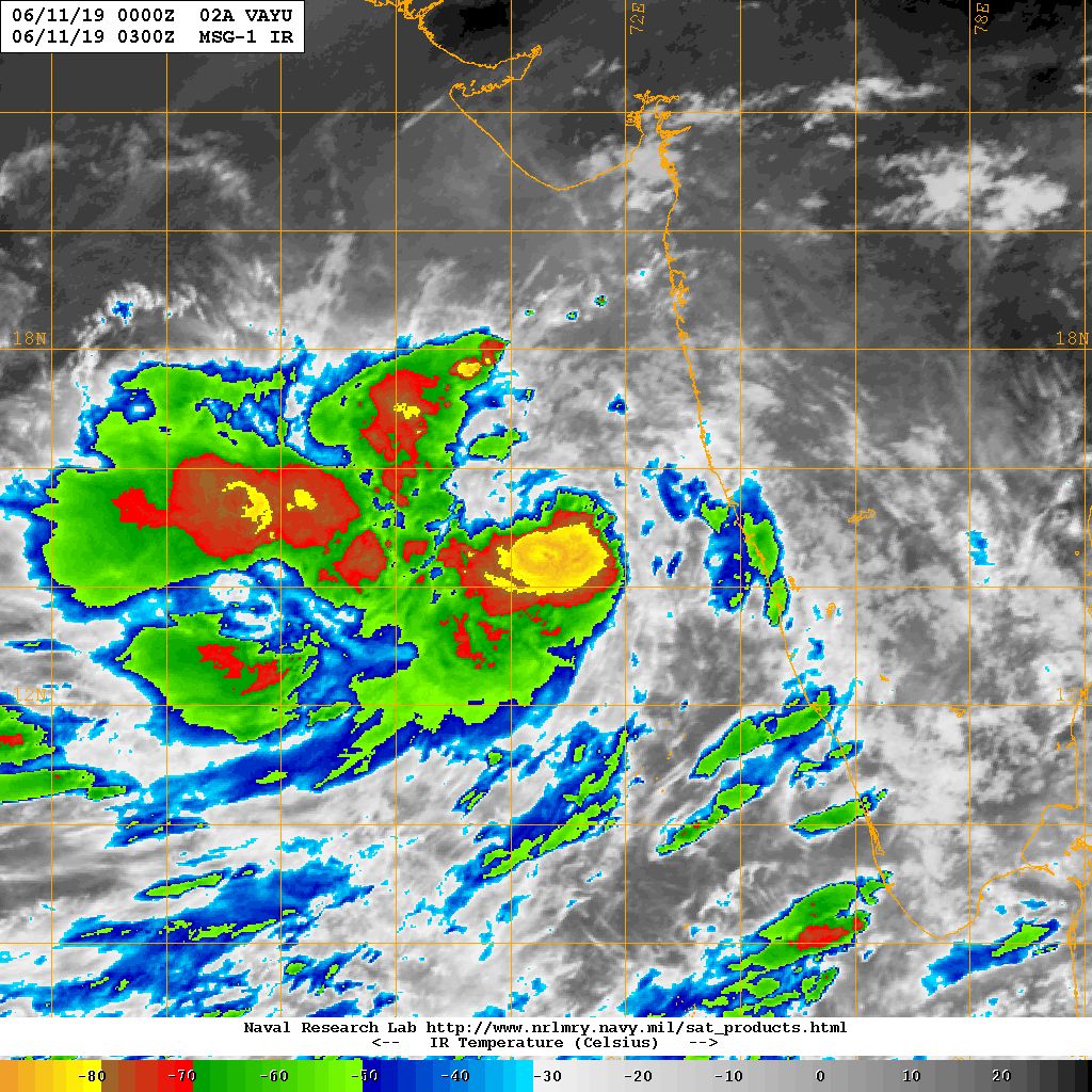
NRL IR Satellite Image 02A.VAYU Dated 11th June 2019 @ 0300UTC (08.30 am. IST)
For specific locations forecast please use this link or any other forecast model to see weather for your location.
https://meteologix.com/in
જુદા જુદા સેન્ટર માટે ની આગાહી માટે આ લિંક માં તમારા સેન્ટર નું નામ નાખી આગાહી જોય લેવાની અથવા બીજા કોઈ પણ ફોરકાસ્ટ મોડલ નો ઉપયોગ કરો.
Forecast: Saurashtra, Gujarat & Kutch 11th To 15th June 2019
The Cyclonic Storm “VAYU” is now over Eastcentral Arabian Sea and it is expected to track Northerly direction during the next two days towards Saurashtra Coast. There is all likely hood of high winds accompanied with extremely high rainfall in the Coastal areas of Saurashtra & Kutch during 12th to 15th June.
અપડેટ:
સૌરાષ્ટ્ર, ગુજરાત અને કચ્છ: તારીખ 11 થી 15 જૂન 2019
વાવાઝોડું “વાયુ” હવે મધ્ય પૂર્વ અરબી સમુદ્ર ઉપર આવી ગયું છે અને હજુ મજબૂત બનશે તેવું અનુમાન છે. આવતા બે દિવસ મુખ્યત્વે ઉત્તર બાજુ ગતિ કરશે અને ત્યાર બાદ ઉત્તર ઉત્તર પશ્ચિમ બાજુ ગતિ કરશે. સિસ્ટમ સૌરાષ્ટ્ર તરફ આવતી હોય સૌરાષ્ટ્ર ના દરિયાપટ્ટી ના જિલ્લાઓ માં તેમજ કચ્છ માં વધુ પવન અને સાથે અતિ ભારે વરસાદ પાડવાની સંભાવના છે માટે સાવચેત રહેવું તારીખ 12 જૂન થી 15 જૂન 2019.
Caution: Please refer/rely on IMD/RSMC Bulletins/Advisories for Storms & Weather related matter.
સાવચેતી: સ્ટોર્મ કે હવામાન અંગે ની માહિતી માટે ભારતીય હવામાન ખાતા/ગવર્મેન્ટ ના બુલેટીન/સુચના પર નિર્ભર રહેવું.
