Current Weather Conditions on 28th June 2019
As per IMD :
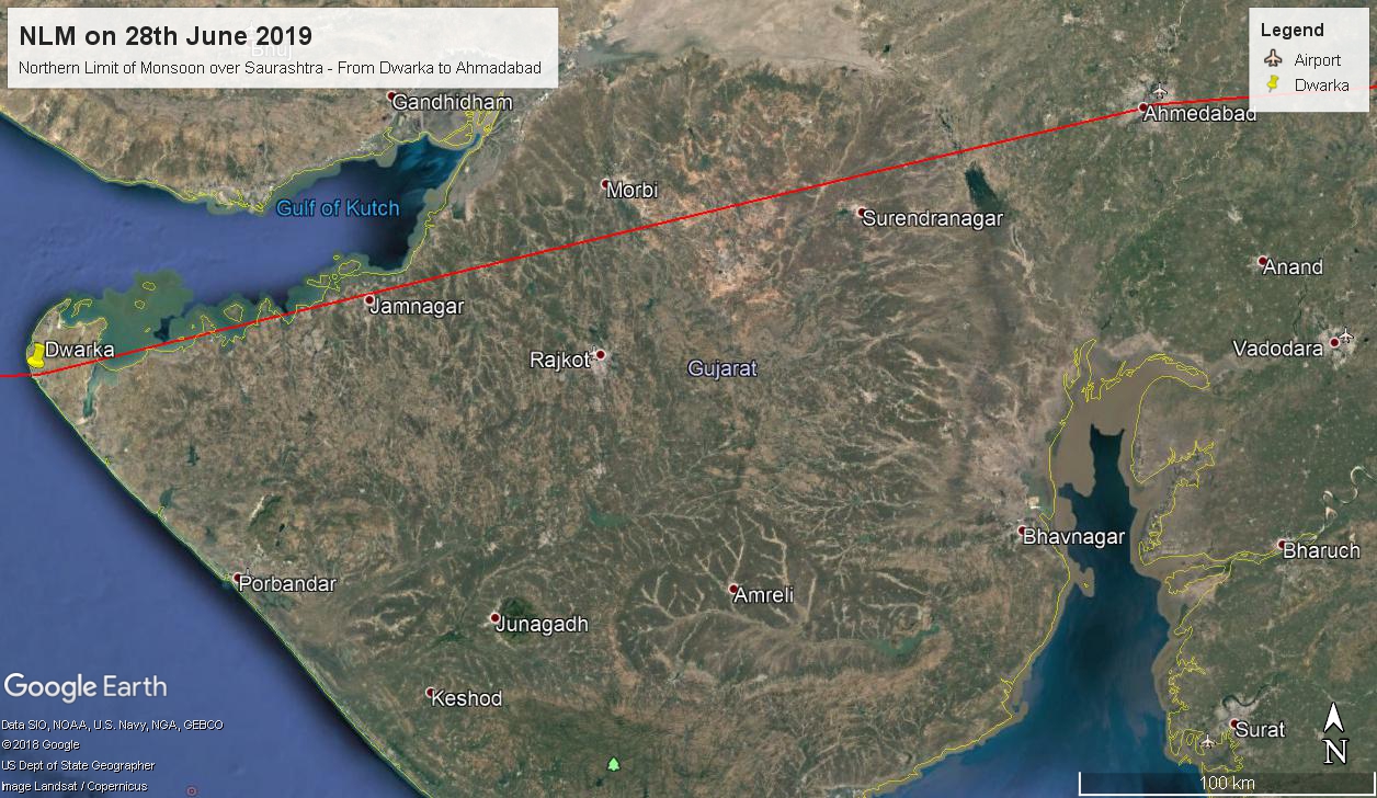
Southwest monsoon has further advanced into some more parts of north Arabian Sea, Gujarat & Madhya Pradesh. Northern Limit of Monsoon (NLM) passes through Lat. 22°N/Long. 60°E, Lat. 22°N/Long. 65°E, Dwarka, Ahmedabad, Bhopal, Jabalpur, Pendra, Sultanpur, Lakhimpur Kheri, Mukteshwar and Lat. 31°N/Long. 80°E.
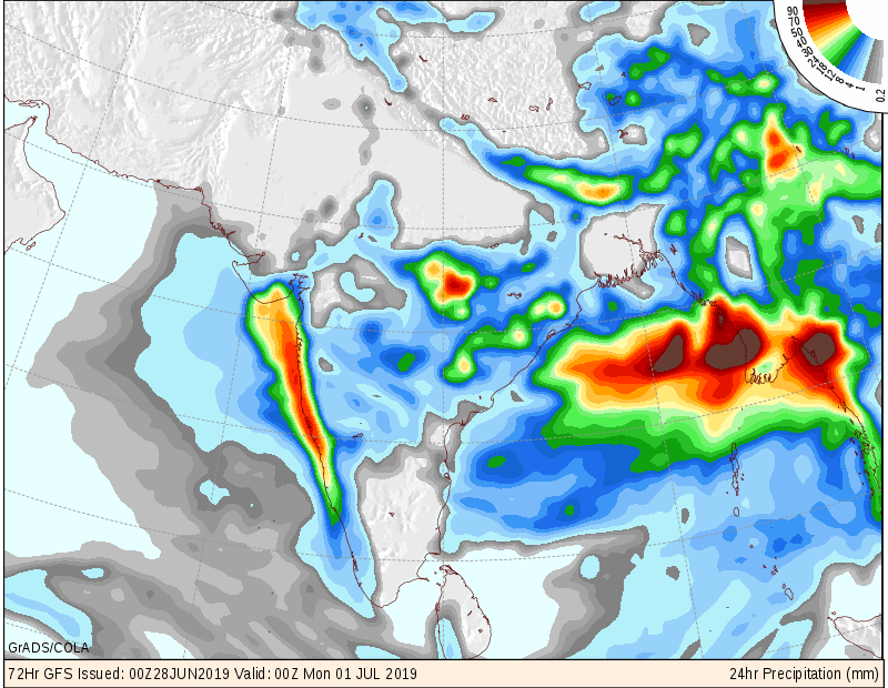
A Low Pressure Area is very likely to form over north Bay of Bengal & neighborhood around 30th June, which is likely to become more marked and concentrate into a Depression during the subsequent 48 hours .
In association with this, conditions are likely to become favorable for further advance of Southwest Monsoon into remaining parts of central India and some more parts of West & northwest India during 1st -3rd July.
The cyclonic circulation over south Pakistan & neighborhood now lies over central Pakistan & neighborhood and extends up to 1.5 km above mean sea level.
The trough at mean sea level now runs from northern parts of Punjab to Manipur across Haryana, North Uttar Pradesh, North Bihar, Sub-Himalayan West Bengal and Assam.
The cyclonic circulation over south Madhya Pradesh and neighborhood persists and now seen at 3.1 km above mean sea level.
The cyclonic circulation over Westcentral Bay of Bengal off North Andhra Pradesh- South Odisha coasts persists and now extends between 4.5 km & 7.6 km above mean sea level tilting Southwestwards with height.
IMD Advance Of Southwest Monsoon Map
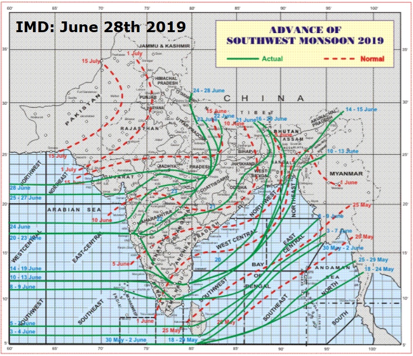
સૌથી ઉપર ની લીલી લીટી ના છેડે જે તારીખ હોઈ તે તારીખે લીટી ની નીચે ના ભાગ માં બધે ચોમાસું પોંચી ગયું છે તેમ સમજવું.
લાલ ત્રુટક લીટી જે તે વિસ્તાર માં નોર્મલ ચોમાસું બેસવાની તારીખ દર્શાવે છે
The date shown at the end of green line shows that the Southwest Monsoon has set in over areas below the green line on that date.
The red dashed line shows the normal date of onset of Southwest Monsoon over various regions
Saurashtra, Gujarat & Kutch: 28th June to 30th June 2019
Southwest Monsoon has set in over major portions of Saurashtra & Gujarat today. The NLM passes through 22N &65E to Dwarka, Ahmadabad, Bhopal and on wards to Jabalpur and Pendra, Sultanpur, Lakhimpur Kheri, Mukteshwar and Lat. 31°N/Long. 80°E.
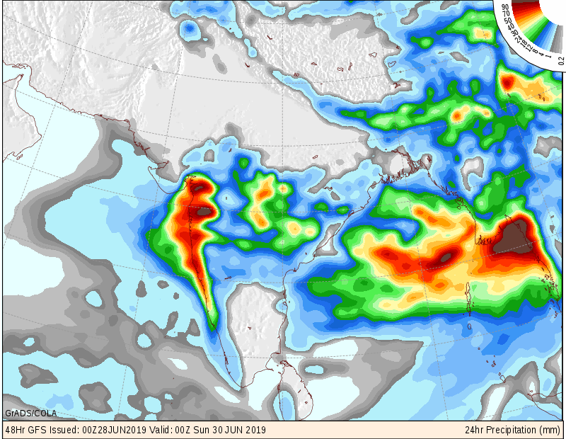
Average rainfall in last 24 hours over Saurashtra was 4 mm (Total average 93 mm. till date)
Average rainfall in last 24 hours over South Gujarat was 27 mm (Total average 80 mm. till date)
Average rainfall in last 24 hours over East Central Gujarat was 7 mm (Total average 64 mm. till date)
Average rainfall in last 24 hours over North Gujarat was 4 mm (Total average 88 mm. till date)
Forecast:
South Gujarat & East Central Gujarat could receive Medium/Heavy Rainfall with Isolated very Heavy Rainfall during forecast period.
25% of All areas covered by Monsoon in Saurashtra could receive Medium/Heavy Rainfall while 75% areas could receive Scattered Showers/Light Rainfall, with Isolated Medium Rainfall during forecast period.
Pre-monsoon activity to continue over Kutch and rest of Saurashtra & Gujarat that is not covered by Monsoon during forecast period.
A Low Pressure Area is very likely to form over north Bay of Bengal & neighborhood around 30th June, which is likely to become more marked and concentrate into a Depression during the subsequent 48 hours . This System is expected to affect Saurashtra, Gujarat & Kutch (70% chance), so update of its potential effects will be given in a few days.
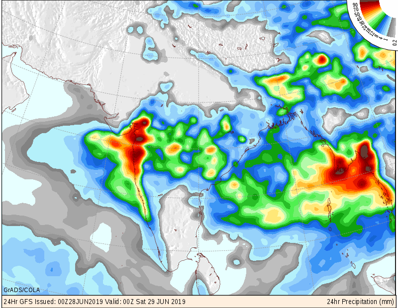
Monsoodata Maps (COLA) for next three days is given below:
સૌરાષ્ટ્ર, ગુજરાત અને કચ્છ: તારીખ 28 જૂન થી 30 જૂન 2019
દક્ષિણ પશ્ચિમ ચોમાસુ સૌરાષ્ટ્ર અને ગુજરાત ના મોટા ભાગો માં બેસી ગયું. ચોમાસુ રેખા હવે દ્વારકા થી અમદાવાદ થઇ ને ભોપાલ તરફ જાય છે. એટલે પોરબંદર, રાજકોટ, ભાવનગર, જૂનાગઢ વિગેરે માં ચોમાસુ બેસી ગયું.
છેલ્લા 24 કલાક માં સૌરાષ્ટ્ર વિસ્તાર માં શરેરાશ 4 મિમી થયેલ છે ( કુલ શરેરાશ વરસાદ આ મહિના માં 93 મિમી )
છેલ્લા 24 કલાક માં દક્ષિણ ગુજરાત વિસ્તાર માં શરેરાશ 27 મિમી થયેલ છે ( કુલ શરેરાશ વરસાદ આ મહિના માં 80 મિમી )
છેલ્લા 24 કલાક માં મધ્ય પૂર્વ માં શરેરાશ 7 મિમી થયેલ છે ( કુલ શરેરાશ વરસાદ આ મહિના માં 64 મિમી )
છેલ્લા 24 કલાક માં ઉત્તર ગુજરાત વિસ્તાર માં શરેરાશ 4 મિમી થયેલ છે ( કુલ શરેરાશ વરસાદ આ મહિના માં 88 મિમી )
ઉપરોક્ત આંકડા માં “વાયુ” વાવાઝોડા ને હિસાબે પડેલ વરસાદ પણ સામેલ છે.
આગાહી:
દક્ષિણ ગુજરાત અને મધ્ય પૂર્વ ગુજરાત માં આવતા બેક દિવસ માં મધ્યમ/ભારે વરસાદ ની શક્યતા છે તો ક્યાંક ક્યાંક અતિ ભારે વરસાદ ની શક્યતા આગાહી સમય માં.
ચોમાસુ બેસી ગયું હોય તેવા સૌરાષ્ટ્ર ના 25% વિસ્તારો માં માધ્યમ/ભારે વરસાદ ની શક્યતા છે, તો ક્યાંક ક્યાંક અતિ ભારે વરસાદ ની શક્યતા આગાહી સમય માં.
ચોમાસુ બેસી ગયું હોય તેવા બાકી સૌરાષ્ટ્ર ના 75% વિસ્તારો માં છુટા છવાયા ઝાપટા/હળવો વરસાદ તો ક્યાંક ક્યાંક મધ્યમ વરસાદ ની શક્તા આગાહી સમય માં.
ચોમાસુ ના બેઠું હોય તેવા કચ્છ, બાકી રહેતા સૌરાષ્ટ્ર તેમજ ગુજરાત ના ભાગો માં પ્રિ મોન્સૂન એક્ટિવિટી ચાલુ રહેશે.
મોન્સૂન ડેટા (COLA) ના વરસાદ માટે ના નકશા આગાહી સમય ના આપેલ છે.
બંગાળ ની ખાડી માં 30 જૂન આસપાસ લો પ્રેસર થવા ની શક્યતા છે તેમજ આ સિસ્ટમ મજબૂત બની ડિપ્રેસન થઇ શકે. આ સિસ્ટમ ની સૌરાષ્ટ્ર, ગુજરાત અને કચ્છ ને અસર કરે તેવી હાલ 70% શક્યતા છે માટે તેની અપડેટ આવતા દિવસો માં આવશે.
Caution: Please refer/rely on IMD/RSMC Bulletins/Advisories for Storms & Weather related matter.
સાવચેતી:
સ્ટોર્મ કે હવામાન અંગે ની માહિતી માટે ભારતીય હવામાન ખાતા/ગવર્મેન્ટ ના બુલેટીન/સુચના પર નિર્ભર રહેવું.