Update on 21st July 2018
Daily Rainfall figures are here
Gujarat Dam Rainfall figures are here
Gujarat Dam storage details are here
Current Meteorological features based on IMD Bulletin :
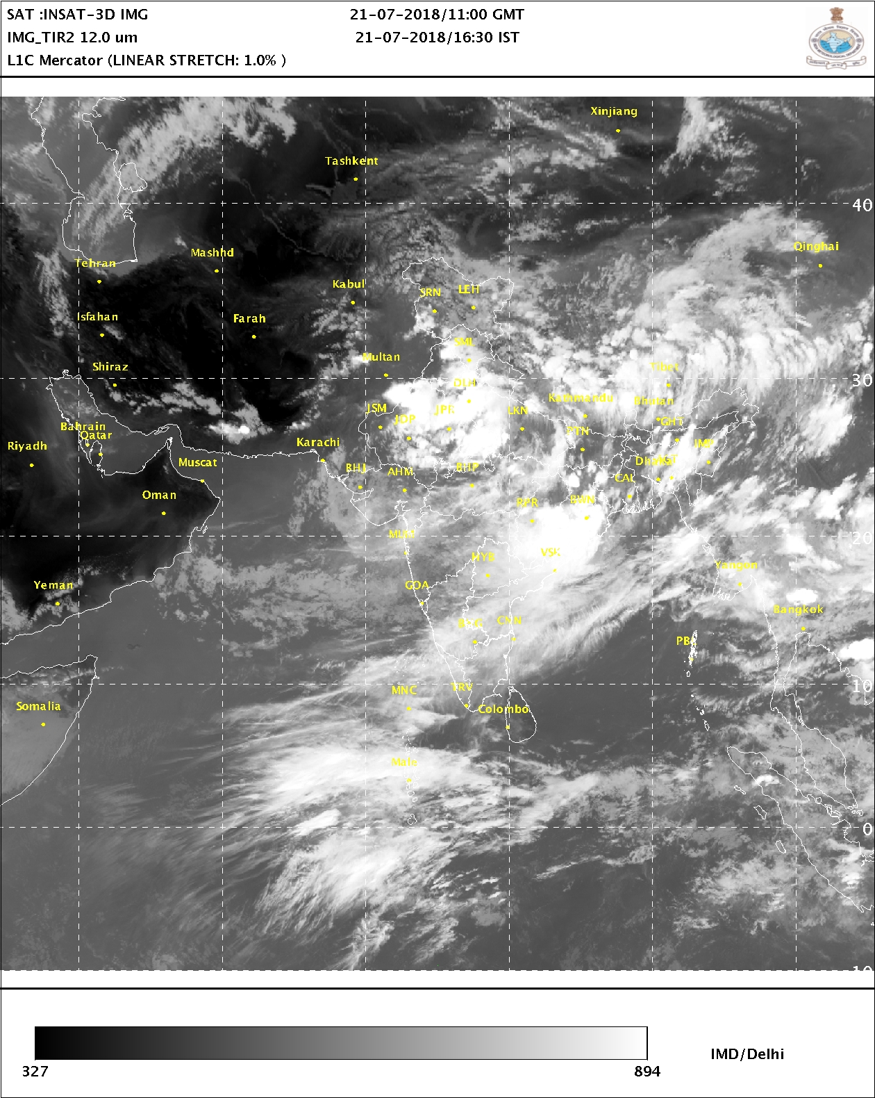
The Well Marked Low Pressure area over Northwest Bay of Bengal & adjoining West Bengal and Odisha coasts concentrated into a Depression this morning the 21st July 2018 near latitude 21.0°N and longitude 88.0°E, about 120 km East Southeast of Balasore. System is expected to track West Northwestwards and cross North Odisha vicinity of Balasore by tonight, the 21st July 2018.
The Axis of Monsoon trough at mean sea level now passes through Anupgarh, Jaipur, Shivpuri, Tikamgarh, Varanasi, Jamshedpur, Center of Depression over NW Bay of Bengal and thence to Eastcentral Bay of Bengal and extends up to 2.1 km above mean sea level.
A Trough at 3.1 km above mean sea level is over Saurashtra, Gulf of Khambhat & Adjoining South Gujarat.
The feeble off-shore trough at mean sea level runs from South Gujarat coast to North Kerala coast.
Saurashtra, Gujarat & Kutch: 23rd to 27th July 2018
Bay of Bengal Depression System is expected to track West Northwestwards during the next 2/3 days and reach Madhya Pradesh. Due to this System there is a good chance of rainfall over M.P./Gujarat border areas, East Central Gujarat and adjoining North Gujarat, South Gujarat during 23rd to 27th July 2018. There is also possibility of good rain for Districts of Bhavnagar, Amreli & Gir Somnath during this period. Details for Saurashtra & Kutch as well as Gujarat will be updated on 23rd July.
Windy conditions expected over Saurashtra/Kutch for next few days. Cloudy weather on most days.
Caution: Please refer/rely on IMD/RSMC Bulletins/Advisories for Storms & Weather related matter.
હાલ ની પરિસ્થિતિ અને નિચોડ: 21 જુલાઈ 2018
ઓડિશા પશ્ચિમ બંગાળ ના કિનારા નજીક બંગાળ ની ખાડી માં 19 તારીખે લો પ્રેસર થયું।. 20 તારીખે મજબૂત બની વેલ માર્કંડ લો થયું જે આજે વધુ મજબૂત બની ને ડિપ્રેસન માં પરિવર્તિત થયું. બાલાસોર થી 120 કિમિ પૂર્વ દક્ષિણ પૂર્વ પર છે. આજે રાત્રી સુધી માં ઓડિશા ના બાલાસોર આસપાસ થી જમીન પર આવશે.
ચોમાસુ ધરી અનૂપગઢ, જયપુર, વારાણસી, જમશેદપુર, ડિપ્રેસન સેન્ટર અને ત્યાંથી મધ્ય પૂર્વ બંગાળ ની ખાડી તરફ લંબાય છે અને 2.1 કિમિ ની ઉંચાઈ સુધી ફેલાયેલ છે.
એક અપર એર ટ્રફ 3.1 કિમિ ની ઉંચાઈએ છે જે સૌરાષ્ટ્ર, ખંભાત ની ખાડી, લાગુ દક્ષિણ ગુજરાત પર છે.
મામૂલી ઓફ શોર ટ્રફ દક્ષિણ ગુજરાત થી નોર્થ કેરળ સુધી સી લેવલ માં છે.
પવન નું જોર રહેશે અને વધુ દિવસો વાદળ છાયું વાતાવરણ રહેશે.
વરસાદ ના આંકડા, ડેમ ઉપર વરસાદ ના આંકડા તેમજ ડેમ સ્ટોરેજ ની વિગત ઉપર લિંક માં આપેલ છે
સૌરાષ્ટ્ર, ગુજરાત અને કચ્છ: તારીખ 23 જુલાઈ થી 27 જુલાઈ 2018
બંગાળ ની ખાડી ની સિસ્ટમ આવતા 2/3 દિવસ પશ્ચિમ ઉત્તર પશ્ચિમ તરફ ગતિ કરી એમપી સુધી પહોંચવાની શક્યતા છે. એટલે પ્રાથમિક અંદાજ મુજબ આ સિસ્ટમ થી ગુજરાત ના એમપી/ગુજરાત બોર્ડર વિસ્તાર, મધ્ય ગજરાત અને લાગુ નોર્થ ગુજરાત, દક્ષિણ ગુજરાત માં વરસાદ ના રાઉન્ડ ની શક્યતા તારીખ 23 થી 27 જુલાઈ દરમિયાન થઇ છે. સૌરાષ્ટ્ર ના ભાવનગર, અમરેલી અને ગીર સોમનાથ જિલ્લા માં પણ આ રાઉન્ડ માં વરસાદ ની શક્યતા. પુરા સૌરાષ્ટ્ર, કચ્છ અને ગુજરાત માટે વિગતવાર અપડેટ 23 જુલાઈ ના થશે.
સાવચેતી:
સ્ટોર્મ કે હવામાન અંગે ની માહિતી માટે ભારતીય હવામાન ખાતા/ગવર્મેન્ટ ના બુલેટીન/સુચના પર નિર્ભર રહેવું.