Current Weather Conditions on 11th July 2017
Monsoon Status based on IMD Inferences:
The Northern Limit of Monsoon (NLM) continues to pass through Lat. 26.0 °N / Long. 70.0°E, Barmer, Sikar, Sonipat, Shimla, Una, Jammu and Lat.32.5°N/Long. 74.5°E.
Favourable conditions are developing for further advance of southwest monsoon into remaining parts of Jammu division and Himachal Pradesh; some more parts of Haryana and some parts of Punjab during next 48 hours.
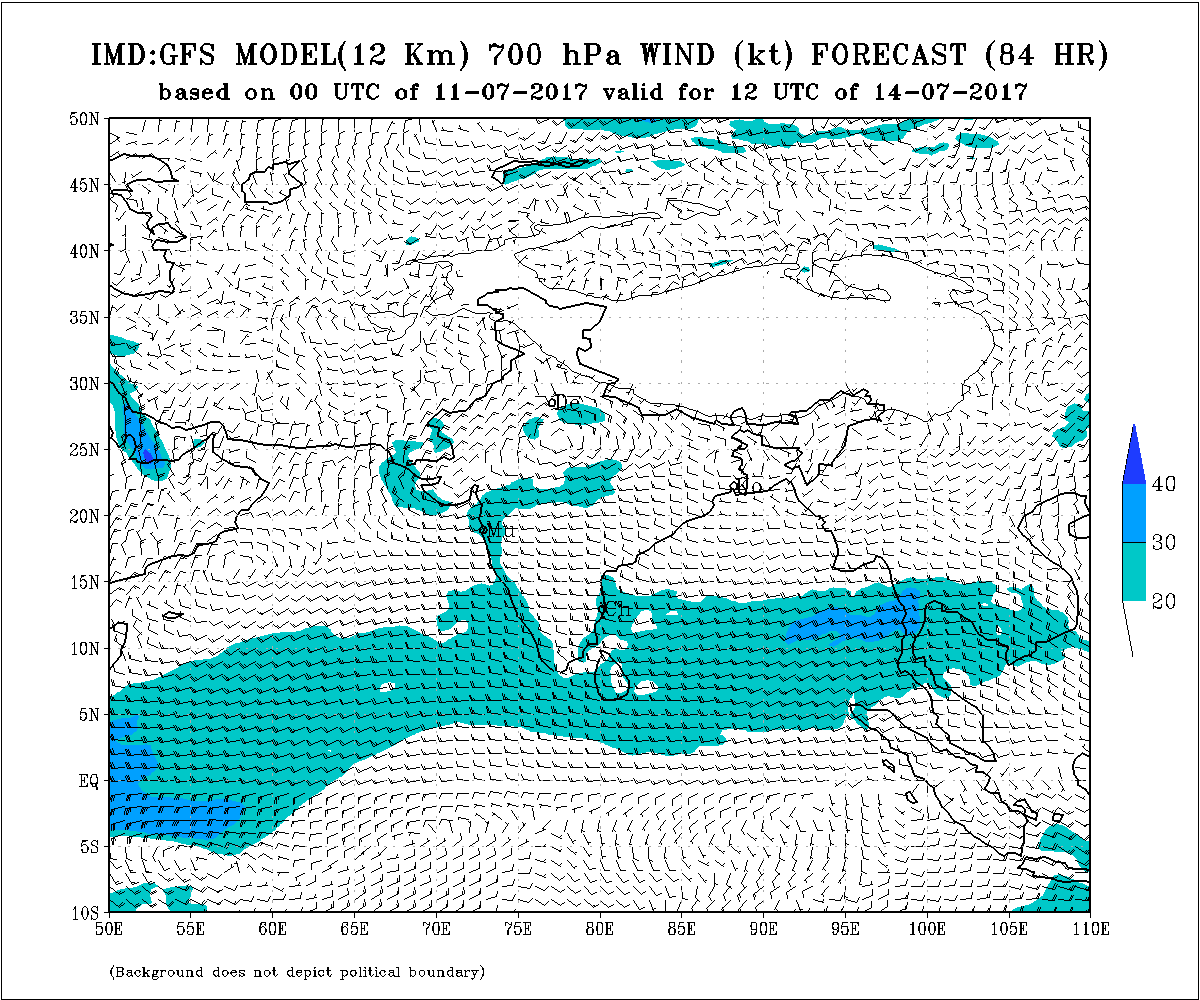
Under the influence of an Upper Air Cyclonic Circulation over East Uttar Pradesh and adjoing area a Low Pressure has developed over East Uttar Pradesh. Associated UAC extends up to 5.8 km above mean sea level.
The trough at mean sea level runs from Punjab to Northwest Bay of Bengal across Center of Low Pressure area over East Uttar Pradesh, Jharkhand, and Gangetic West Bengal.
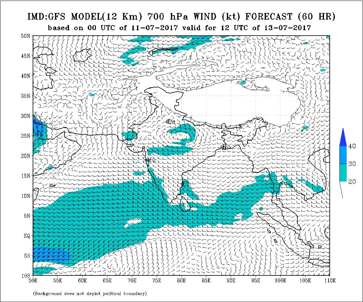
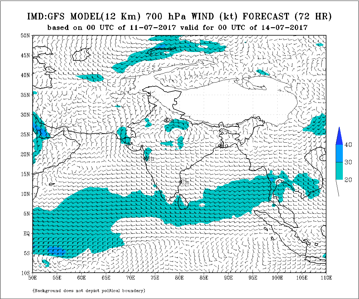
There is an Upper Air Cyclonic Circulation over West Rajasthan & neighborhood extending up to 3.1 km above mean sea level. A trough from this UAC extends to North East Arabian Sea across North Gujarat/Kutch and Saurashtra.
The off-shore trough at mean sea level extends from South Konkan coast to North Kerala coast.
As per IMD:
IMD Advance Of Southwest Monsoon Map
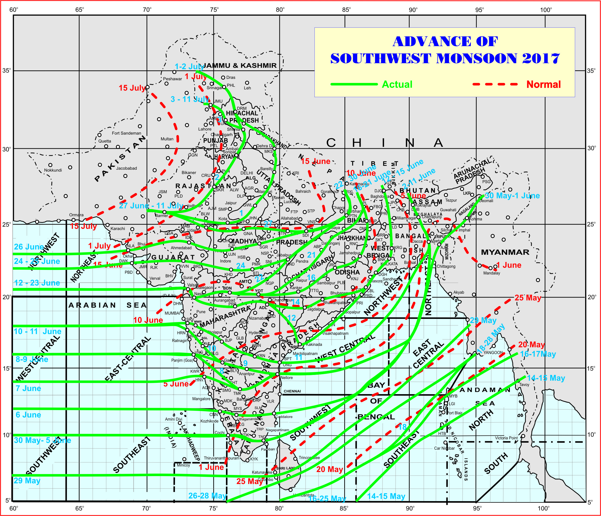
સૌથી ઉપર ની લીલી લીટી ના છેડે જે તારીખ હોઈ તે તારીખે લીટી ની નીચે ના ભાગ માં બધે ચોમાસું પોંચી ગયું છે તેમ સમજવું.
લાલ ત્રુટક લીટી જે તે વિસ્તાર માં નોર્મલ ચોમાસું બેસવાની તારીખ દર્શાવે છે
The date shown at the end of green line shows that the Southwest Monsoon has set in over areas below the green line on that date.
The red dashed line shows the normal date of onset of Southwest Monsoon over various regions.
Weather Forecast: 13th July to 17th July 2017
The UAC over West Rajasthan is expected to move southwards. The Western end of trough at mean sea level currently over Punjab is expected to become normal and subsequently deep towards Gujarat. A broad Circulation at 3.1 km above mean sea level over Gujarat and adjoining Arabian Sea will extend over Madhya Pradesh, Chhattisgarh to West Bengal.
Saurashtra, Kutch & Gujarat :
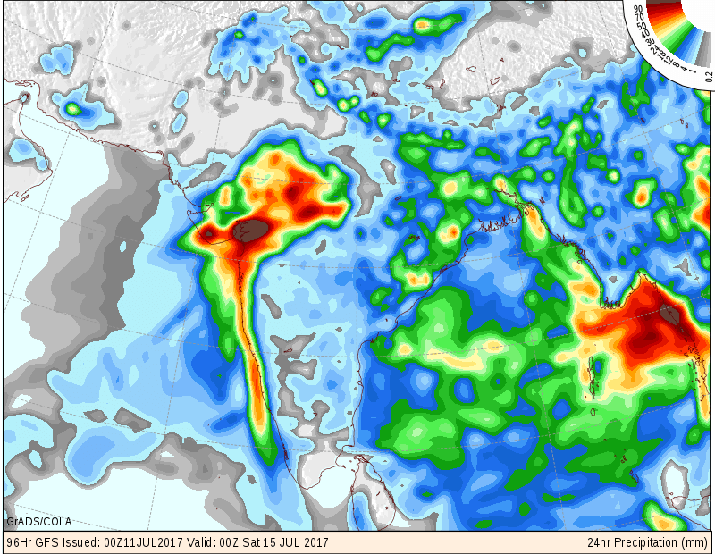
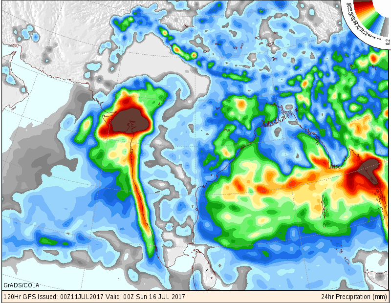
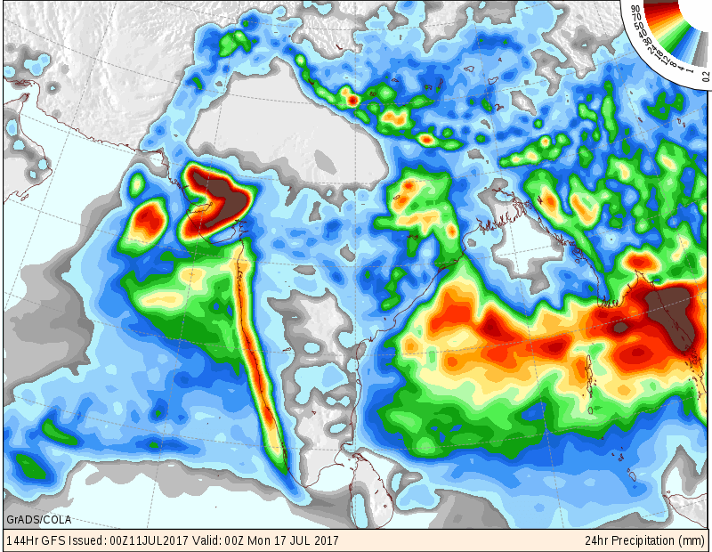
Saurashra, Kutch & Gujarat expected to receive good round of rainfall with medium, heavy to very heavy rainfall during the forecast period. The rain is expected to initially start from Gujarat on 13th July and subsequently Saurashtra & Kutch from 14th July. Areas of very heavy rainfall cumulatively expected to exceed 12 centimeter. scattered showers or light and isolated medium rain to continue for one to two days over whole Gujarat till 12th/13th. Windy conditions over Saurashtra & Kutch will continue and on some days winds could increase further. This rainfall relies on current and potentially developing System and hence update will be given if there is significant change in the outcome.
Note: Refer/rely on IMD Advisories and Weather Bulletins
આગાહી 13 જૂલાઇ થી 17 જૂલાઇ 2017
રાજસ્થાન વાળું UAC આવતા દિવસો માં દક્ષિણ તરફ સરકે તેવું અનુમાન છે. એટલે કે ટ્રફ નો પશ્ચિમ છેડો ગુજરાત સુધી આવે તેવી શક્યતા. તારીખ 13/14 જૂલાઇ ના 3.1 કિમિ ના લેવલે એક બહોળું સર્ક્યુલેશન સૌરાષ્ટ્ર/કચ્છ/ગુજરાત અને લાગુ અરબી સમુદ્ર થી લઇ ને મધ્ય પ્રદેશ, છત્તીસગઢ પશ્ચિમ બંગાળ સુધી ફેલાશે.
સૌરાષ્ટ્ર ગુજરાત અને કચ્છ:
સૌરાષ્ટ્ર ગુજરાત અને કચ્છ માં વરસાદ નો સારો રાઉન્ડ આવે તેવા સંજોગો ઊભા થયા છે, જેથી સમગ્ર ગુજરાત માં મધ્યમ, વરસાદ, ભારે વરસાદ થી અતિ ભારે વરસાદ ની શક્યતા છે. તારીખ 13 ના વરસાદ ગુજરાત બાજુ ચાલુ થશે અને ત્યાર બાદ 14 થી સૌરાષ્ટ્ર અને કચ્છ બાજુ વરસાદ ચાલુ થશે. આ વરસાદ હાલ ની સિસ્ટમ અને આગળ નવી સિસ્ટમ ડેલવેલોપ થશે તેના આધારિત હોય જો વરસાદ ની તીવ્રતા માં બહુ ફેર ફાર હશે તો અપડેટ થશે. સૌરાષ્ટ્ર અને કચ્છ માં તેમજ ગુજરાત ના અમૂક ભાગો માં પવન નું જોર છે જે આગાહી સમય માં ચાલુ રહેશે અને કોઈ કોઈ દિવસ હજુ પવન વધુ વધી શકે છે.
Please follow these guidelines or else comment facility will be disabled for some time.
Guideline for Comments:
1. Please post comment if you have a valid email address.
2. Read earlier comments and their reply before posting any comment.
3. Do not ask question about when the update will take place. Usually as and when deemed fit update will be given.
4. I do not forecast for long term, so do not ask for any forecast beyond 7 days.
5. When will we have ‘Good rain for Sowing seed ? Monsoon onset date has nothing to do with Sowing seeds. The latter is individual farmer’s discretion.
6. Do not ask when it will rain in any city, town or village or city. Normally the forecast is given for broad areas of Saurashtra, Kutch & Gujarat. However, for your information Multicity Wunderground Forecast link has been provided for various centers of Gujarat, Sayrashtra & Kutch.
7. All Comments will not be answered. Comments that is meant for larger audience is preferable and will be answered.
8. Please do not repeat your comment if the comment is in moderation (answer pending ).
9. When ever there is an update or I reply to any comment please do not comment ‘thank you’
કમેન્ટ માટે માર્ગદર્શન:
કમેન્ટ અંગે ના માર્ગદર્શન નો અમલ કરો.
1. ખરું ઈ મેઈલ એડ્રેસ હોઈ તો કમેન્ટ કરો.
2. આગળ સવાલો અને તેના જવાબ વાંચી ને તમારી કમેન્ટ કરો.
3. “અપડેટ ક્યારે થશે ?” તેવા સવાલ કરવા નહિ. સામાન્ય રીતે યોગ્ય લાગશે ત્યારે અપડેટ થશે.
4. હું લાંબા ગાળા ની આગાહી નથી કરતો માટે 7 દિવસ થી આગળ માટે આગાહી બાબત કમેન્ટ ના કરવી.
5. વાવણી લાયક વરસાદ ક્યારે થશે અને ચોમાસુ બેસવું બંને અલગ હોઈ શકે. વાવણી તે ખેડૂત નો નિર્યાય છે.
6. “મારા શહેર, કે ગામ માં વરસાદ ક્યારે થશે ?” તેવા સવાલ પૂછવા નહિ. સામાન્ય રીતે સૌરાષ્ટ્ર, ગુજરાત અને કચ્છ ના બહોળા વિસ્તારો ની આગાહી આપેલ હોઈ છે. તમારા વિસ્તાર ના મોટા સેન્ટર માટે વંડરગ્રાઉન્ડ ની આગાહી ની લિન્ક આપેલ છે અહીં મેનુ માં.
7. જે કમેન્ટ વધુ લોકો ને સ્પર્શતો હોઈ તે આવકાર્ય છે અને તેના યોગ્ય જવાબ મળશે. બધા કમેન્ટ નો જવાબ નહીં મળે.
8. કમેન્ટ મોડરેશન (જવાબ પેન્ડિંગ ) હોઈ બીજી વાર પૂછવું નહીં.
9. અપડેટ આવે એટલે કે જવાબ આપું ત્યારે થૅન્ક યુ ની કોમેન્ટ ના કરવી.