Current Weather Conditions on 4th October 2016
The withdrawal line of Southwest Monsoon continues to pass through Kupwara, Kukernag, Pathankot, Ludhiyana, Churu, Phalodi and Jaisalmer.
Conditions are becoming favorable for withdrawal of Southwest Monsoon from some more parts of Northwest India during the next 48 hours.
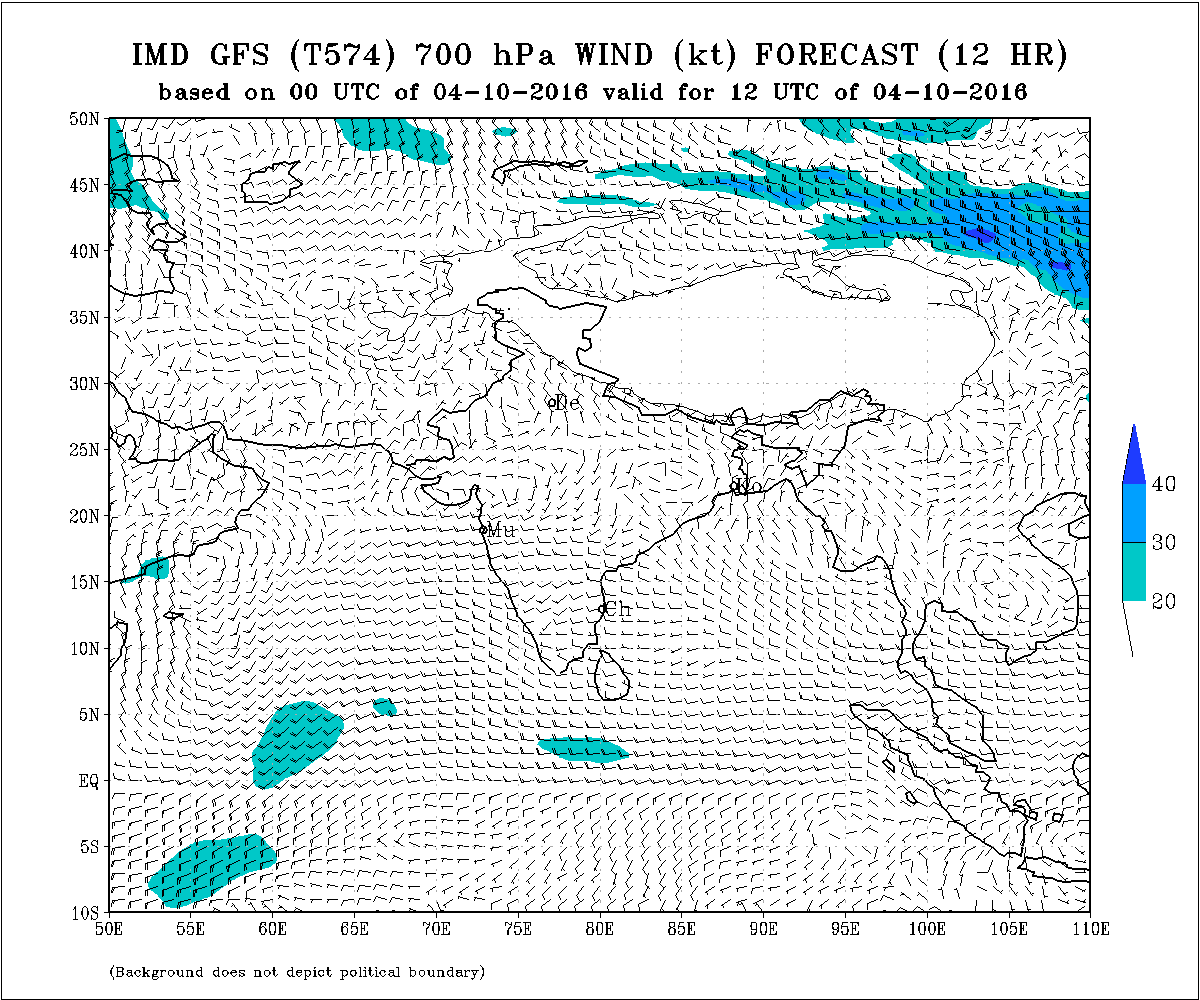
The Upper Air Cyclonic Circulation that was expected to come over Madhya Maharashtra from Vidarbhha area has materialized and today this UAC is over South Gujarat, North Konkan, Gulf Of Khambhat & Adjoining Saurashtra and extends up to 500 hPa.
The western Disturbance as an Upper Air Cyclonic Circulation over Central Parts of Iran & neighborhood is now seen as a trough in Westerlies along 52.0° E and north of latitude 28.0° N between 5.8 km & 7.6 km above mean sea level.
IMD GFS 700 hPa Wind Forecast Chart Valid for 12 UTC 4th October 2016
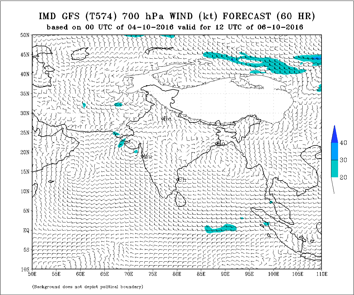
IMD GFS 700 hPa Wind Forecast Chart Valid for 12 UTC 6th October 2016
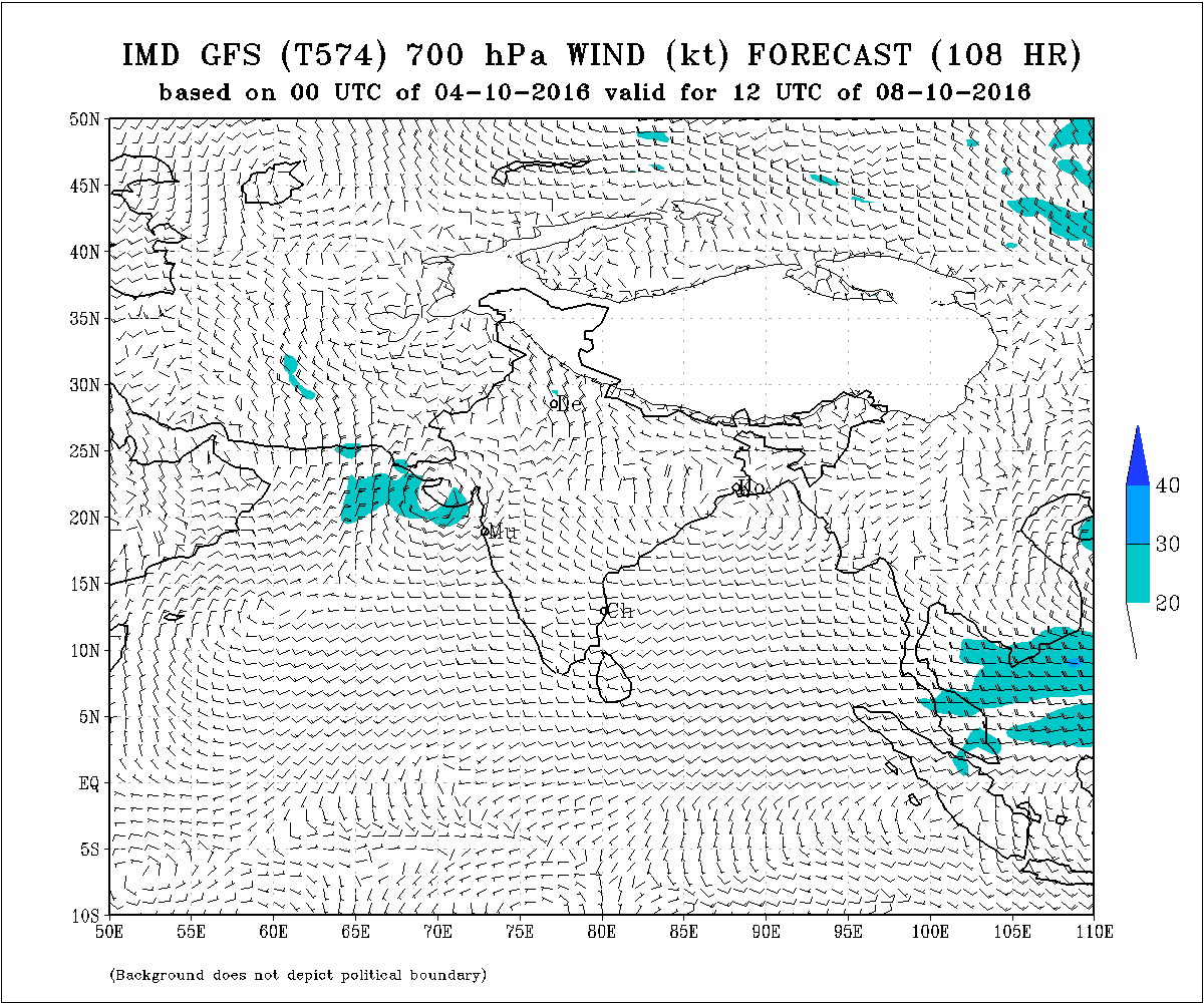
IMD GFS 700 hPa Wind Forecast Chart Valid for 12 UTC 8th October 2016
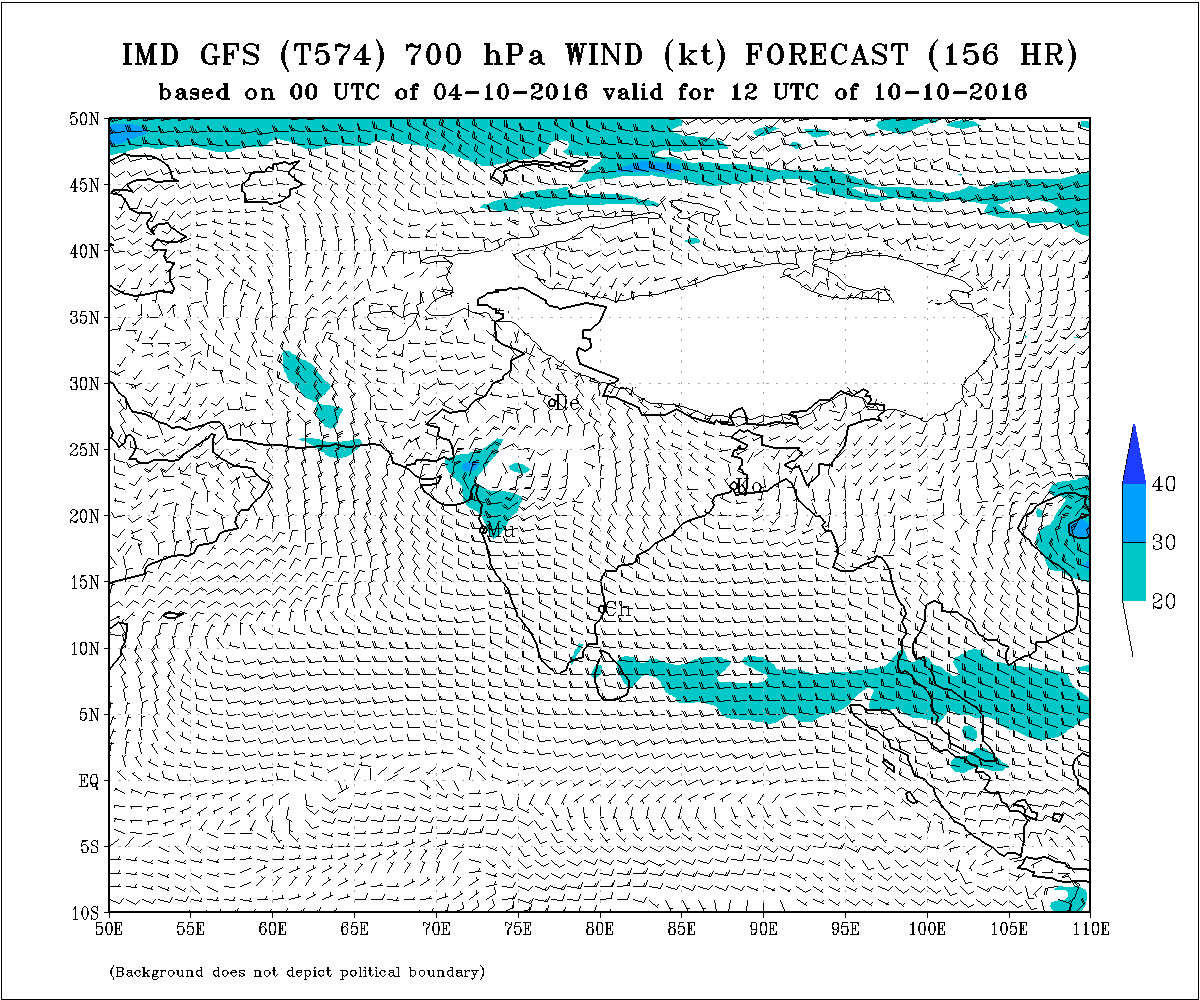
IMD GFS 700 hPa Wind Forecast Chart Valid for 12 UTC 10th October 2016
COLA Precipitation Outlook For Week 1 & Week 2
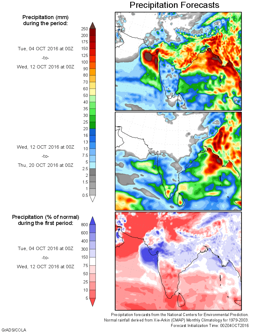
Asian Precipitation NCEP/GFS Bias-Corrected Forecasts
( Background does not depict political boundary )
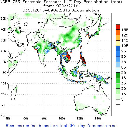
Forecast: 4th October to 10th October 2016
The Upper Air Cyclonic Circulation over Gujarat/North Konkan & vicinity will remain over Saurashtra/Gujarat and nearby Arabian Sea for many days as has been shown in the forecast maps above.
The forecast given is for the duration mentioned and does not imply that it will rain in all the places on all the days. Quantum of rain forecast is cumulative total of the forecast period for various regions. Note: Rainfall figures are forecast in Cm. (1 ich is 2.54 Cms. or approx. 2.5 Cms.)
Saurashtra : Cumulative 5 Cms. to 10 Cms. during the forecast period with isolated places above 10 Cms.
Kutch : Cumulative 2 Cms. to 5 Cms. during the forecast period with isolated places above 5 Cms.
North Gujarat : Cumulative 3 Cms. to 10 Cms. during the forecast period.
East Central Gujarat & South Gujarat : Cumulative 5 Cms. to 10 Cms. during the forecast period.
4th ઓક્ટોબર 2016 :
દક્ષિણ પશ્ચિમ ચોમાસુ આવતા 48 કલાક માં ઉત્તર પશ્ચિમ ભારત ના થોડા વધુ ભાગો માંથી વિદાય લેશે.
મધ્ય મહારાષ્ટ્ર ઉપર યુએસી તારીખ 2 આસપાસ પહોંચવાનું હતું તે પ્રમાણે પહોંચ્યુ. આજે તે યુએસી દક્ષિણ ગુજરાત નોર્થ કોંકણ લાગુ ખંભાત નો અખાત આસપાસ છે અને 5.8 કિમિ ની ઊંચાઈ સુધી ફેલાયેલ છે.
એક વેસ્ટર્ન ડિસ્ટર્બન્સ યુએસી તરીકે ઈરાન ઉપર હતું તે હાલ પશ્ચિમી પવનો ના ટ્રફ તરીકે છે 52.0° E અને latitude 28.0° N થી ઉત્તરે અને 5.8 કિમિ થી 7.6 કિમિ સુધી ફેલાયેલ છે.
આગાહી: 4 થી 10 ઓક્ટોબર 2016
જે યુએસી સૌરાષ્ટ્ર ગુજરાત નજીક આવેલ છે તે યુએસી આવતા ઘણા દિવસો સૌરાષ્ટ્ર, ગુજરાત અને લાગુ ખંભાત નો અખાત અને સૌરાષ્ટ્ર નજીક નો અરબી સમુદ્ર આસપાસ રહેશે.
આ આગાહી સમય દરમ્યાન દર રોજ દરેક જગ્યાએ વરસાદ થશે તેવું સમજવું નહિ. જે તે વિસ્તાર માટે આ આગાહી સમય દરમ્યાન નો અલગ અલગ દિવસ ના વરસાદ ની કુલ માત્રા આપેલ છે. આગાહી સમય પૂર્ણ થયે કોઈ રાઉન્ડ ચાલુ થાય છે કે બંધ થાય છે તેમ સમજવું નહિ. ફક્ત 4 થી10 ઓક્ટોબર સુધી નું પોઝિશન આપેલ છે. વરસાદ ની આગાહી CMs માં આપેલ છે (1 ઇંચ = 2.54 Cms. જે આશરે 2.5 Cms. થાય )
સૌરાષ્ટ્ર : આગાહી સમય દર્મિયાન નો કૂલ વરસાદ 5 Cms. થી 10 Cms. સુધી ની માત્રા અને સીમિત વિસ્તારો માં 10 Cms. થી વધુ ની માત્રા ની શક્યતા છે. સૌરાષ્ટ્ર ના દરેક વિસ્તાર માં વરસાદ ની શક્યતા છે.
કચ્છ : આગાહી સમય દર્મિયાન નો કૂલ વરસાદ 2 Cms. થી 5 Cms. સુધી ની માત્રા અને સીમિત વિસ્તારો માં 5 Cms. થી વધુ ની માત્રા ની શક્યતા છે.
દક્ષિણ ગુજરાત અને મધ્ય પૂર્વ ગુજરાત : આગાહી સમય દર્મિયાન નો કૂલ વરસાદ 5 Cms. થી 10 Cms. સુધી ની માત્રા ની શક્યતા છે
ઉત્તર ગુજરાત : આગાહી સમય દર્મિયાન નો કૂલ વરસાદ 3 Cms. થી 10 Cms. સુધી ની માત્રા ની શક્યતા છે.
Caution: Please refer/rely on IMD/RSMC Bulletins/Advisories for Storms & Weather related matter.
Please follow these guidelines or else comment facility will be disabled for some time.
Guideline for Comments:
1. Please post comment if you have a valid email address.
2. Read earlier comments and their reply before posting any comment.
3. Do not ask question about when the update will take place. Usually as and when deemed fit update will be given.
4. I do not forecast for long term, so do not ask for any forecast beyond 7 days.
5. Do not ask when it will rain in any city, town or village or city. Normally the forecast is given for broad areas of Saurashtra, Kutch & Gujarat. However, for your information Multicity Wunderground Forecast link has been provided for various centers of Gujarat, Sayrashtra & Kutch.
6. All Comments will not be answered. Comments that is meant for larger audience is preferable and will be answered.
7. Please do not repeat your comment if the comment is in moderation (answer pending ).
સાવચેતી:
સ્ટોર્મ કે હવામાન અંગે ની માહિતી માટે ભારતીય હવામાન ખાતા/ગવર્મેન્ટ ના બુલેટીન/સુચના પર નિર્ભર રહેવું.
કમેન્ટ માટે માર્ગદર્શન:
કમેન્ટ અંગે ના માર્ગદર્શન નો અમલ કરો નહીંતર ના છૂટકે કમેન્ટ વ્યવસ્થા હાલ પૂરતી બંધ કરવા માં આવશે.
1. ખરું ઈ મેઈલ એડ્રેસ હોઈ તો કમેન્ટ કરો.
2. આગળ સવાલો અને તેના જવાબ વાંચી ને તમારી કમેન્ટ કરો.
3. “અપડેટ ક્યારે થશે ?” તેવા સવાલ કરવા નહિ. સામાન્ય રીતે યોગ્ય લાગશે ત્યારે અપડેટ થશે.
4. હું લાંબા ગાળા ની આગાહી નથી કરતો માટે 7 દિવસ થી આગળ માટે આગાહી બાબત કમેન્ટ ના કરવી.
5. “મારા શહેર, કે ગામ માં વરસાદ ક્યારે થશે ?” તેવા સવાલ પૂછવા નહિ. સામાન્ય રીતે સૌરાષ્ટ્ર, ગુજરાત અને કચ્છ ના બહોળા વિસ્તારો ની આગાહી આપેલ હોઈ છે. તમારા વિસ્તાર ના મોટા સેન્ટર માટે વંડરગ્રાઉન્ડ ની આગાહી ની લિન્ક આપેલ છે અહીં મેનુ માં.
6. જે કમેન્ટ વધુ લોકો ને સ્પર્શતો હોઈ તે આવકાર્ય છે અને તેના યોગ્ય જવાબ મળશે. બધા કમેન્ટ નો જવાબ નહીં મળે.
7. કમેન્ટ મોડરેશન (જવાબ પેન્ડિંગ ) હોઈ બીજી વાર પૂછવું નહીં.
Weather Forecast In Akila Daily Dated 4th October 2016
Will be updated later
Weather Forecast In Sanj Samachar Daily Dated 4th October 2016
Will be updated later