Current Weather Conditions on 21st August 2016
The Deep Depression from Northwest Madhya pradesh tracked mainly Westwards and weakened three notches and now is a Low Pressure area over East Rajasthan & adjoining West Madhya Pradesh in morning of 21st August 2016. The associated Upper Air Cyclonic Circulation now extends up to 7.6 km above mean sea level.
The Axis of Monsoon trough at mean sea level continue to pass through Bikaner, Center of Low Pressure area over East Rajasthan & adjoining West Madhya Pradesh, Satna, Varanasi, Bhagalpur, Center of Low Pressure area over Bangladesh & neighborhood and thence Southeastwards to Northeast Bay of Bengal.
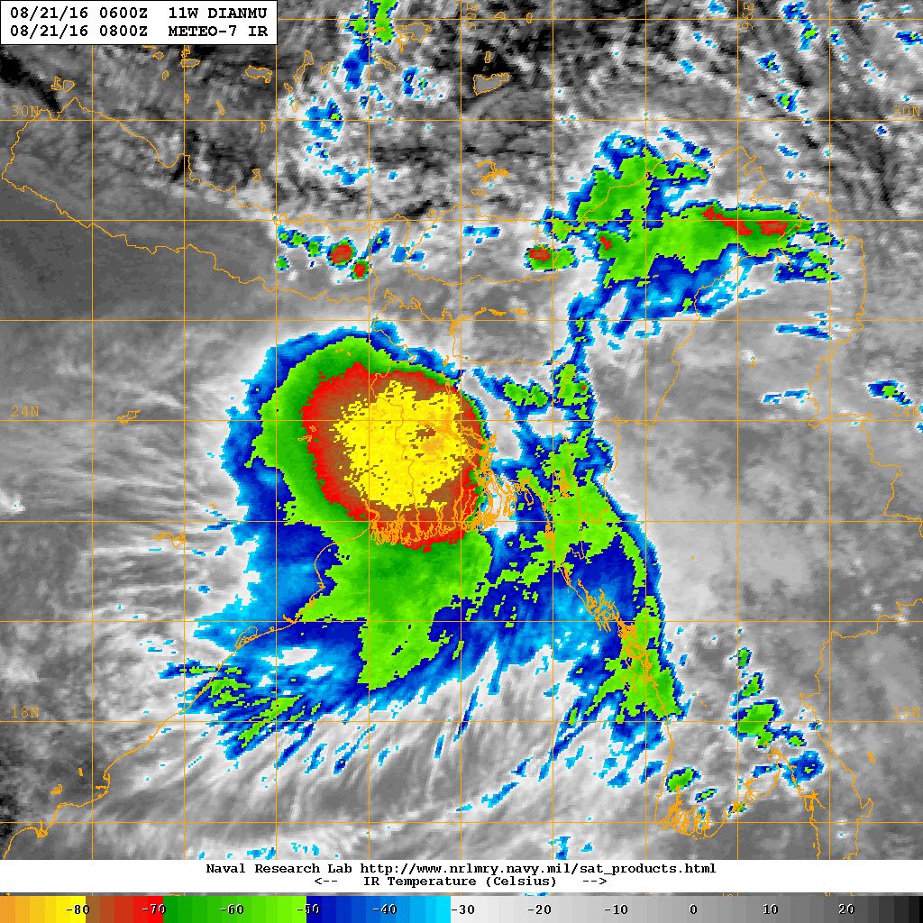
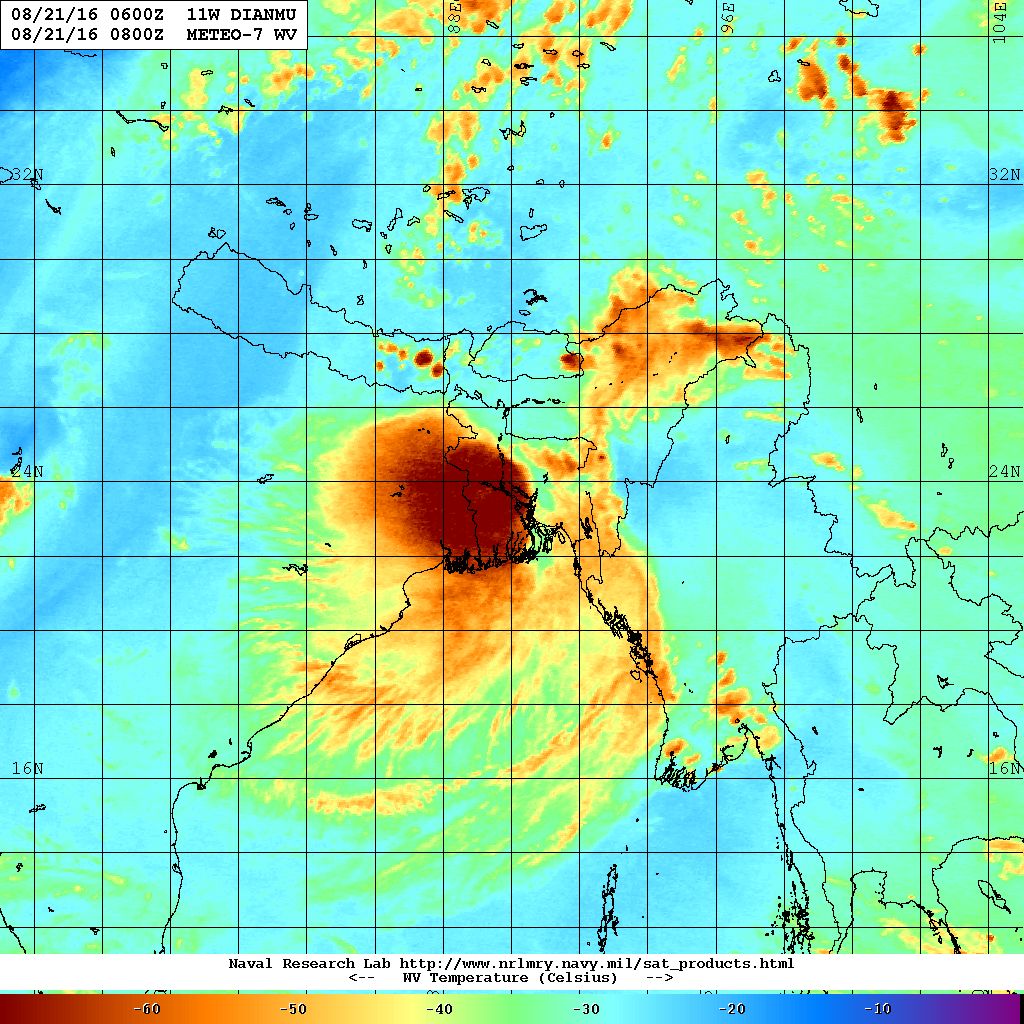
The Low pressure area over Myanmar is now located over Bangladesh & neighborhood at 23.3 N & 90.0E. The associated Upper Air Cyclonic Circulation extends up to Mid-tropospheric levels. The System is now a Well Marked Low Pressure area.
The Western Disturbance as a trough in Mid-tropospheric Westerlies roughly along Long. 64.0°E and North of Lat. 28.0°N.
Myanmar System now over Bangla Desh (Well Marked Low Pressure) original 11W.Dianmu location was Lat. 23.2 N & Long. 90.0 E at 0600 UTC 21st August 2016 about 2100 km. East of Rajkot.
NRL IR Satellite Image of 11W.DIANMU ( WMLP ) on 21st August 2016 @ 0800 UTC (01.30 pm. IST)
NRL Water Vapor Satellite Image of 11W.DIANMU ( WMLP ) on 21st August 2016 @ 0800 UTC (01.30 pm. IST)
Forecast dated 20th August still valid, however, updates will be given about the progress of the System currently over Bangladesh & neighborhood.
બંગલા દેશ વળી સિસ્ટમ (વેલ માર્કંડ લો પ્રેસર ) 11W.Dianmu લોકેશન Lat. 23.2 N & Long. 90.0 E આજે સવારે 11.30 કલાકે 21st August 2016 ના રાજકોટ થી 2100 દૂર પૂર્વે હતી.
તારીખ 20 ઓગસ્ટ ની આગાહી હજુ અમલ માં છે,છતાં પૂર્વ બાજુ થી જે નવી સિસ્ટમ આવી રહી છે તેની પ્રગતિ દર રોજ કરવા માં આવશે.
Forecast: 20th August to 26th August 2016
Saurashtra & Kutch : Mixed weather with Sun & Clouds. Only light rain or scattered showers on some days. The current Depression over NW Madhya Pradesh will not benefit Saurashtra in a big way.
Gujarat: Light medium rain on some days and some places receiving heavy rain. Main beneficiary will be Gujarat Districts bordering Rajasthan & Madhya Pradesh.
Note: ECMWF forecast model shows likelyhood of better rainfall for Saurashtra, Gujarat & Kutch during 24-26th Augsut due to the new Low Pressure System over Myanmar, however, GSF does not show this possibility. Hence the situation has to be monitored during the next two days. This Low Pressure is yet over Myanmar and has a long way to come to Gujarat.
સૌરાષ્ટ્ર અને કચ્છ: સૂર્ય અને વાદળો વાળું મિક્સ વાતાવરણ।. હાલ અમૂક દિવસે ઝાપટા હળવો વરસાદ ની શક્યતા છે. હાલ નું ડિપ્રેસન થી સૌરાષ્ટ્ર ને મોટો ફાયદો નહિ થાય.
ગુજરાત : અમૂક દિવસો માં હળવો મધ્યમ વરસાદ અને કોઈ કોઈ જગ્યાએ ભારે વરસાદ ખાસ કરીને એમપી અને રાજસ્થાન ને લાગુ ગુજરાત ની બોર્ડર ડીસ્ટ્રીકટ.
નોંધ: ECMWF ફોરકાસ્ટ મોડલ મુજબ 24 થી 26 દરમિયાન નવા લો પ્રેસર થી સૌરાષ્ટ્ર ગુજરાત અને કચ્છ ને ફાયદો થાય તેવી ધારણા છે પરંતુ GSF ફોરકાસ્ટ મોડલ મુબજ ખાસ કઈ ફાયદો નથી દર્શાવતો માટે બેએક દિવસ માં એની વધુ સ્પષ્ટતા થશે. આ સિસ્ટમ હજુ મ્યાનમાર માં છે માટે તેનું કઈ નક્કી ના રહે કારણ કે પલ્લો ઘણો કાપવાનો છે.