Current Weather Conditions on 2nd August 2016
The Low Pressure area over Northwest Bay of Bengal off West Bengal & North Odisha coasts and the associated Upper Air Cyclonic circulation extending up to Mid-tropospheric levels persists.The system could become a Well Marked Low Pressure area during next two days.
The axis of monsoon trough at mean sea level continues to pass through Anupgarh, Narnaul, Orai, Daltonganj, Digha, Center of Low Pressure area and thence Eastsoutheastwards to Northeast Bay of Bengal and extends up to 1.5 Km above mean sea level.
There is an Upper Air Cyclonic Circulation over East Rajasthan – Northwest Madhya Pradesh and adjoining Gujarat border and now extends up to 3.1 km above sea level. A broad Circulation from this UAC will at times extend up to the UAC associated with the Bay Of Bengal Low Pressure area.
There is an off-shore trough at mean sea level from Gujarat to Karnataka coast.
Forecast: 2nd August to 7th August 2016
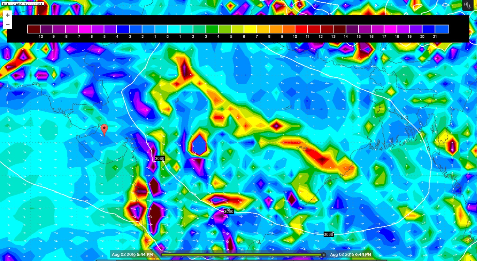
Wunderground GFS 700 hPa Chart Valid for 2nd August 2016 @ 1200 UTC
Wunderground GFS 700 hPa Chart Valid for 3rd August 2016 @ 1200 UTC

Saurashtra, Kutch & Gujarat: 2nd August to 7th August 2016
South Gujarat will receive Medium to Heavy rain during the forecast period on most days.
Gujarat Districts bordering Rajasthan & Madhya Pradesh will receive Medium to Heavy rain on 2 & 3 rd August. Rest of the forecast period Scattered light/medium/heavy rain on different days over different places of these Districts.
Saurashtra, Kutch & rest of Gujarat expected to get scattered light rain to medium rain on different days over different places of the forecast period.
Note: There is differing outcome from GSF and ECMWF forecast models. As per ECMWF there is also possibility for good rain over SOuthwest Rajasthan, Sindh & Kutch.
Caution: Please refer/rely on IMD/RSMC Bulletins/Advisories for Storms & Weather related matter.
Please follow these guidelines or else comment facility will be disabled for some time.
Guideline for Comments:
1. Please post comment if you have a valid email address.
2. Read earlier comments and their reply before posting any comment.
3. Do not ask question about when the update will take place. Usually as and when deemed fit update will be given.
4. I do not forecast for long term, so do not ask for any forecast beyond 7 days.
5. Do not ask when it will rain in any city, town or village or city. Normally the forecast is given for broad areas of Saurashtra, Kutch & Gujarat. However, for your information Multicity Wunderground Forecast link has been provided for various centers of Gujarat, Sayrashtra & Kutch.
6. All Comments will not be answered. Comments that is meant for larger audience is preferable and will be answered.
7. Please do not repeat your comment if the comment is in moderation (answer pending ).
અપડેટ 2 ઓગસ્ટ 2016
ઉત્તર બંગાળ ની ખાડી માં ગઈ કાલે એક લો પ્રેસર થયુ છે. તેના અનૂસંગિક યુએસી મીડ ટ્રોપોસ્ફીયરિક લેવલ સુધી છે. આ લો મજબૂત બની શકે છે.
ચોમાસુ ધરી નો પશ્ચિમ છેડો અનૂપગઢ, નારનોલ, દલોતગંજ, દીઘા અને લો પ્રેસર સેન્ટર અને ત્યાંથી ઉત્તર પૂર્વ બંગાળ ની ખાડી તરફ લંબાય છે.
એક યુએસી પૂર્વ રાજસ્થાન અને નોર્થ વેસ્ટ એમ.પી. અને લાગુ ગુજરાત બોર્ડર સુધી 3.1 કિમી ની ઊંચાયે છે. ક્યારેક ક્યારેક આ યુએસી નું બહોળું સર્કુલેસન બંગાળ ની ખાડી ના લો પ્રેસર અનૂસંગિક યુએસી સુધી લંબાશે.
ઑફ શોર ટ્રફ ગુજરાત ના કાંઠા થી કર્ણાટક ના કાંઠા સુધી લંબાય છે.
આગાહી: 2 ઓગસ્ટ થી 7 ઓગસ્ટ 2016
સૌરાષ્ટ્ર ગુજરાત અને કચ્છ:
આગાહી સમય માં દક્ષિણ ગુજરાત માં લગભગ દિવસો માં મધ્યમ/ભારે વરસાદ પડવાની શક્યતા છે.
રાજસ્થાન અને મધ્ય પ્રદેશ ને લાગુ ગુજરાત ના જિલ્લા ઓ માં મધ્યમ /ભારે વરસાદ 2 તારીખ અને 3 ઓગસ્ટ ના. બાકી ના આગાહી સમય માં સૌરાષ્ટ્ર, કચ્છ અને બાકી નું ગુજરાત ની આગાહી લાગુ પડશે.
સૌરાષ્ટ્ર, કચ્છ અને બાકી નું ગુજરાત માં હળવો/મધ્યમ વરસાદ અલગ અલગ દિવસે અલગ અલગ વિસ્તાર માં પડેશે.
નોંધ: વિવિદ્ધ ફોરકાસ્ટ મોડલ માં મત મતાંતર છે. યુરોપિયન ફોરકાસ્ટ મોડલ મુબજ રાજસ્થાન એમપી ઉપર જે યુએસી છે તેની અસર દક્ષિણ પશ્ચિમ રાજસ્થાન , સિંધ અને કચ્છ ને પણ ફાયદો કરે તેવું દર્શાવે છે.
સાવચેતી:
સ્ટોર્મ કે હવામાન અંગે ની માહિતી માટે ભારતીય હવામાન ખાતા/ગવર્મેન્ટ ના બુલેટીન/સુચના પર નિર્ભર રહેવું.
કમેન્ટ માટે માર્ગદર્શન:
કમેન્ટ અંગે ના માર્ગદર્શન નો અમલ કરો નહીંતર ના છૂટકે કમેન્ટ વ્યવસ્થા હાલ પૂરતી બંધ કરવા માં આવશે.
1. ખરું ઈ મેઈલ એડ્રેસ હોઈ તો કમેન્ટ કરો.
2. આગળ સવાલો અને તેના જવાબ વાંચી ને તમારી કમેન્ટ કરો.
3. “અપડેટ ક્યારે થશે ?” તેવા સવાલ કરવા નહિ. સામાન્ય રીતે યોગ્ય લાગશે ત્યારે અપડેટ થશે.
4. હું લાંબા ગાળા ની આગાહી નથી કરતો માટે 7 દિવસ થી આગળ માટે આગાહી બાબત કમેન્ટ ના કરવી.
5. “મારા શહેર, કે ગામ માં વરસાદ ક્યારે થશે ?” તેવા સવાલ પૂછવા નહિ. સામાન્ય રીતે સૌરાષ્ટ્ર, ગુજરાત અને કચ્છ ના બહોળા વિસ્તારો ની આગાહી આપેલ હોઈ છે. તમારા વિસ્તાર ના મોટા સેન્ટર માટે વંડરગ્રાઉન્ડ ની આગાહી ની લિન્ક આપેલ છે અહીં મેનુ માં.
6. જે કમેન્ટ વધુ લોકો ને સ્પર્શતો હોઈ તે આવકાર્ય છે અને તેના યોગ્ય જવાબ મળશે. બધા કમેન્ટ નો જવાબ નહીં મળે.
7. કમેન્ટ મોડરેશન (જવાબ પેન્ડિંગ ) હોઈ બીજી વાર પૂછવું નહીં.
Weather Forecast In Akila Daily Dated 2nd August 2016