Current Weather Conditions on 27th June 2016
There has been scattered showers and light rain from 22nd June 2016 over some parts of Saurashtra & South Gujarat with few places receiving medium rainfall especially Coastal Saurashtra.
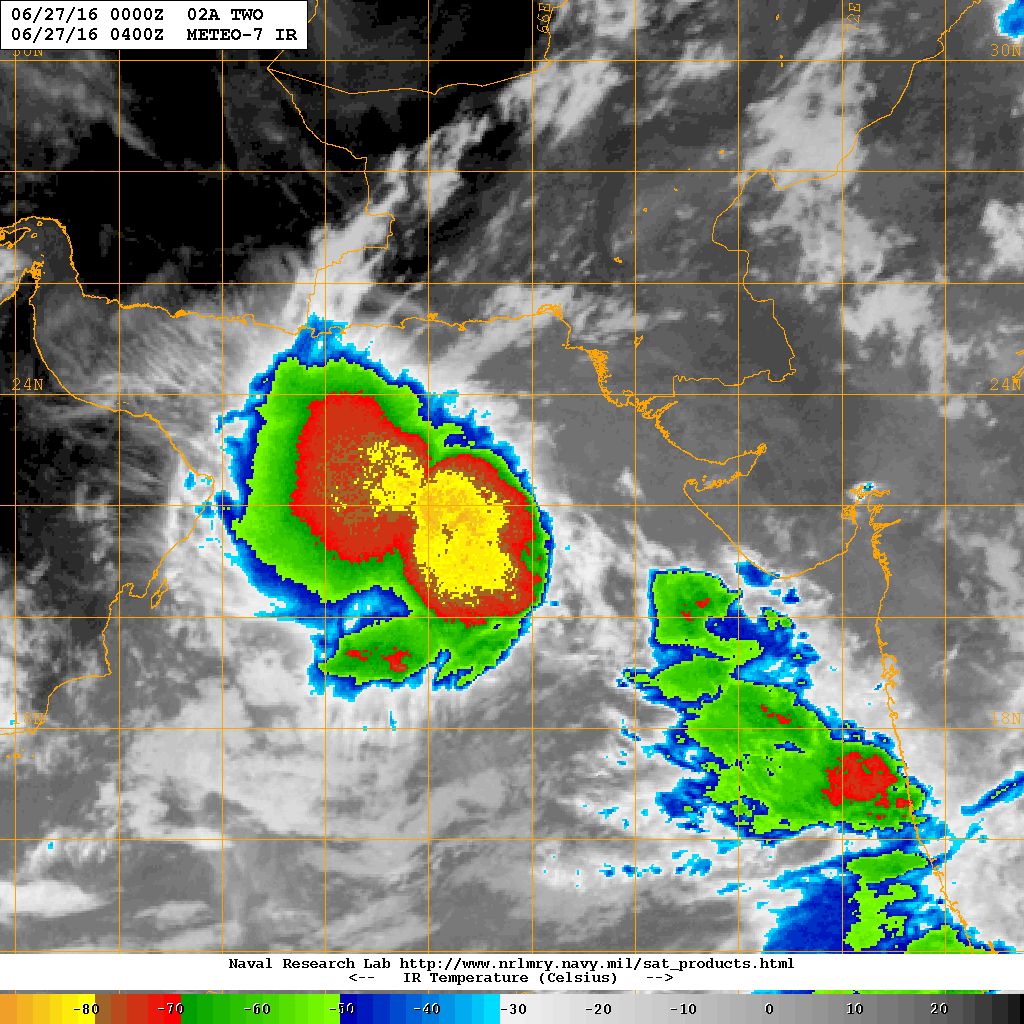
The Upper Air Cyclonic Circulation over South Gujarat & adjoining North Konkan had tracked along the Saurashtra coast and moved away to Northeast Arabian Sea as a Low Pressure and has now attained Depression strength (Depression strength confirmation by IMD/RSMC is yet pending) , located 21.9N Lat. & 66.4 E. Long. about 300 Kms. West of Dwarka, Saurashtra.
The Low Pressure area off South Odisha & North Andhra Pradesh coast and associated UAC extends up to 5.8 Km above mean sea level.
The trough at mean sea level from Punjab to Eastcentral Bay of Bengal across Haryana, North Madhya Pradesh, Chhatisgarh and Odisha and Center of Low Pressure area extending upto 0.9 km above mean sea level persists.
An off shore trough at mean sea level extends from South Gujarat to Kerala.
A western disturbance as a trough in midtropospheric westerlies runs roughly along longitude 62.0° E and latitude north of 30.0°N.
NRL IR Satellite Image on 27th June 2016 @ 04.00 UTC (09.30 am. IST)
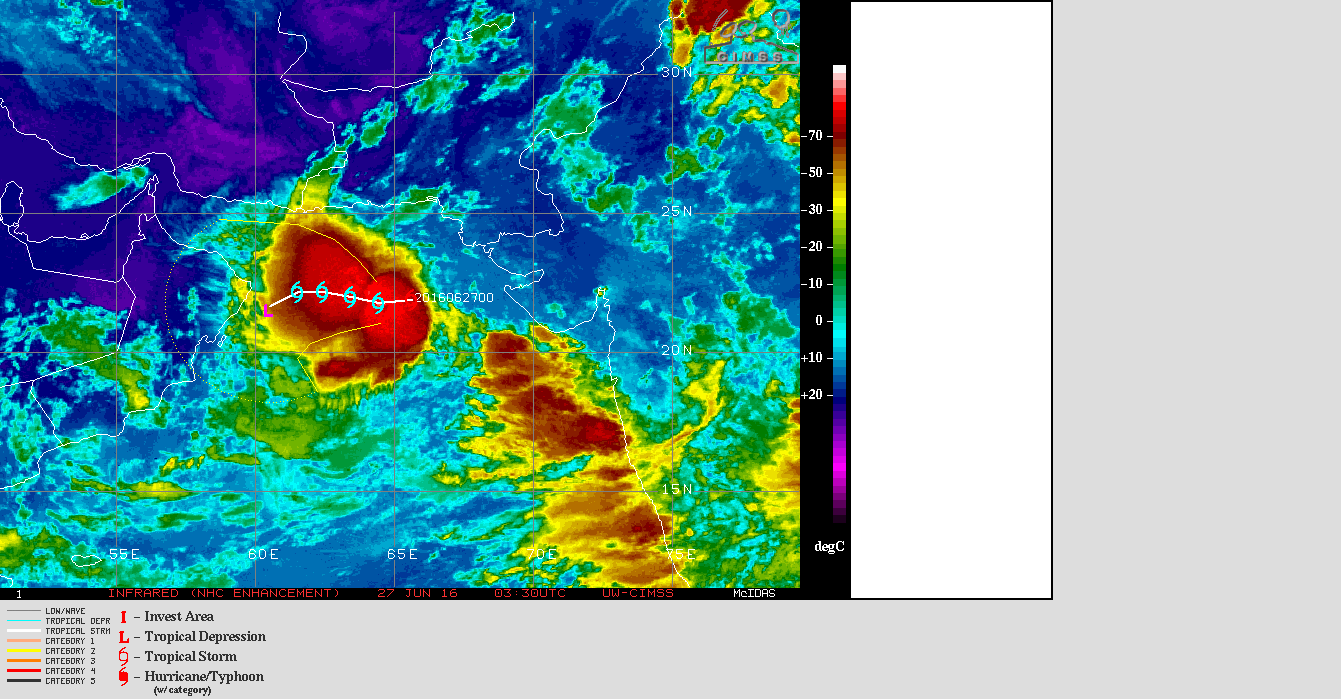
UV-CIMSS IR Satellite Image of 02A.TWO With Forecast Track on 27th June 2016 @ 03.30 UTC ( 09.00 am. IST )
(System strength to be confirmed by IMD/RSMC)
Caution: Please refer/rely on IMD/RSMC Bulletins/Advisories for Storms & Weather related matter.
સાવચેતી:
સ્ટોર્મ કે હવામાન અંગે ની માહિતી માટે ભારતીય હવામાન ખાતા/ગવર્મેન્ટ ના બુલેટીન/સુચના પર નિર્ભર રહેવું.
તારીખ 26 જૂન 2016 દક્ષિણ પશ્ચિમ ચોમાસુ સૌરાષ્ટ્ર અને ગુજરાત માં હવામાન ખાતા એ ચોમાસુ રેખા આગળ ધપાવી.
તારીખ 27 ના ચોમાસુ આગળ નથી ચાલ્યું.
IMD Advance Of Southwest Monsoon Till 26th June 2016
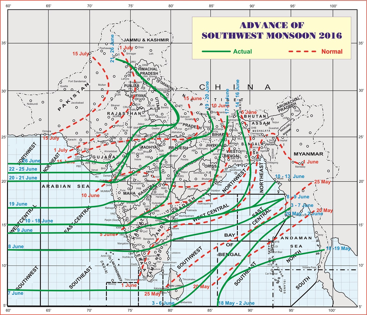
લીલી લીટી ના છેડે જે તારીખ હોઈ તે તારીખે લીટી ની નીચે ના ભાગ માં બધે ચોમાસું પોંચી ગયું છે તેમ સમજવું.
લાલ ત્રુટક લીટી જે તે વિસ્તાર માં નોર્મલ ચોમાસું બેસવાની તારીખ દર્શાવે છે
The date shown at the end of green line shows that the Southwest Monsoon has set in over areas below the green line on that date.
The red dashed line shows the normal date of onset of Southwest Monsoon over various regions.
Guideline for Comments:
1. Please post comment if you have a valid email address.
2. Read earlier comments and their reply before posting any comment.
3. Do not ask question about when the update will take place. Usually as and when deemed fit update will be given.
4. I do not forecast for long term, so do not ask for any forecast beyond 7 days.
5. Do not ask when it will rain in any city, town or village or city. Normally the forecast is given for broad areas of Saurashtra, Kutch & Gujarat.
કમેન્ટ માટે માર્ગદર્શન:
1. ખરું ઈ મેઈલ એડ્રેસ હોઈ તો કમેન્ટ કરો.
2. આગળ સવાલો અને તેના જવાબ વાંચી ને તમારી કમેન્ટ કરો.
3. “અપડેટ ક્યારે થશે ?” તેવા સવાલ કરવા નહિ. સામાન્ય રીતે યોગ્ય લાગશે ત્યારે અપડેટ થશે.
4. હું લાંબા ગાળા ની આગાહી નથી કરતો માટે 7 દિવસ થી આગળ માટે આગાહી બાબત કમેન્ટ ના કરવી.
5. “મારા શહેર, કે ગામ માં વરસાદ ક્યારે થશે ?” તેવા સવાલ પૂછવા નહિ. સામાન્ય રીતે સૌરાષ્ટ્ર, ગુજરાત અને કચ્છ ના બહોળા વિસ્તારો ની આગાહી આપેલ હોઈ છે.