Current Weather Conditions on 20th June 2016
The Southwest Monsoon has further advanced into remaining parts of Central Arabian Sea, Konkan, Marathwada and Vidarbha, most parts of Madhya Maharashtra, some parts of Southwest Madhya Pradesh and some more parts of East Madhya Pradesh.
The Northern Limit of Monsoon (NLM) passes through Lat. 20.0°N/ Long. 60.0°E, Lat. 20.0°N/ Long.70.0°E,
Dahanu, Malegaon, Pachmarhi, Jabalpur, Sidhi, Patna and Raxaul.
Conditions are favorable for further advance of Southwest Monsoon into some parts of North Arabian Sea,
Coastal Saurashtra, South Gujarat region, remaining parts of Madhya Maharashtra, some more parts of Madhya Pradesh and East Uttar
Pradesh and remaining parts of Bihar by 22nd June 2016.
The trough at mean sea level now runs from North Rajasthan to Westcentral Bay of Bengal
across Madhya Pradesh, Vidarbha, Telangana & coastal Andhra Pradesh and extends up to
1.5 km above mean sea level.
The Upper Air Cyclonic Circulation over Vidarbha & neighborhood persists and now extends
between 1.5 & 5.8 km above mean sea level, tilting Southwestwards with height.
An Upper Air Cyclonic Circulation lies over Southwest Madhya Pradesh & neighborhood and extends upto 0.9
km above mean sea level.
A fresh Upper Air Cyclonic Circulation likely to form over Central Bay of Bengal around 22nd June.
An East-West shear zone at 500 hPa level runs roughly along lat 10°N.
The feeble off-shore trough at mean sea level from Coastal Karnataka to Kerala coast persists.
તારીખ 20 જૂન 2016 ના દક્ષીણ પશ્ચિમ ચોમાસું સમગ્ર મધ્ય અરબી સમુદ્ર, મુંબઈ સહીત કોંકણ મરાઠવાડા અને વિદર્ભ માં બેસી ગયુ તેમજ મધ્ય મહારાષ્ટ્ર ના લગભગ ભાગો, પૂર્વ એમપી ના થોડા વધુ ભાગો, અને દક્ષીણ પશ્ચિમ એમપી ના થોડા ભાગ માં આગળ ચાલ્યું.
બંગાળ ની ખાડી વાળુ UAC હવે વિદર્ભ આસપાસ છે અને તે 1.5 કિમી થી 4.5 કિમી ની ઊંચાઈ સુધી ફેલાયેલ છે.
દક્ષીણ પશ્ચિમ એમપી નજીક એક UAC 0.9 કિમી ની ઊંચાઈ એ છે.
IMD Advance Of Southwest Monsoon Till 20th June 2016
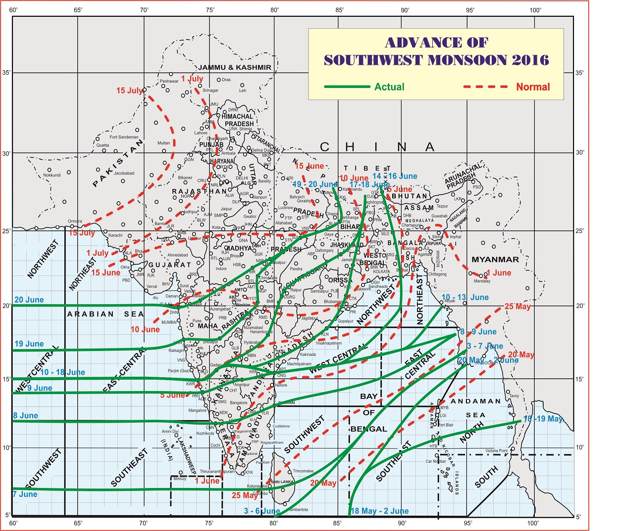
લીલી લીટી ના છેડે જે તારીખ હોઈ તે તારીખે લીટી ની નીચે ના ભાગ માં બધે ચોમાસું પોંચી ગયું છે તેમ સમજવું.
લાલ ત્રુટક લીટી જે તે વિસ્તાર માં નોર્મલ ચોમાસું બેસવાની તારીખ દર્શાવે છે
The date shown at the end of green line shows that the Southwest Monsoon has set in over areas below the green line on that date.
The red dashed line shows the normal date of onset of Southwest Monsoon over various regions.
Weekly Forecast for Saurashtra, Gujarat & Kutch will be published on 21-06-2016
Weather Forecast In Akila Daily Dated 20th June 2016
Weather Forecast In Sanj Samachar Daily Dated 20th June 2016
Guideline for Comments:
1. Please post comment if you have a valid email address.
2. Read earlier comments and their reply before posting any comment.
3. Do not ask question about when the update will take place. Usually as and when deemed fit update will be given.
4. I do not forecast for long term, so do not ask for any forecast beyond 7 days.
5. Do not ask when it will rain in any city, town or village or city. Normally the forecast is given for broad areas of Saurashtra, Kutch & Gujarat.
કમેન્ટ માટે માર્ગદર્શન:
1. ખરું ઈ મેઈલ એડ્રેસ હોઈ તો કમેન્ટ કરો.
2. આગળ સવાલો અને તેના જવાબ વાંચી ને તમારી કમેન્ટ કરો.
3. “અપડેટ ક્યારે થશે ?” તેવા સવાલ કરવા નહિ. સામાન્ય રીતે યોગ્ય લાગશે ત્યારે અપડેટ થશે.
4. હું લાંબા ગાળા ની આગાહી નથી કરતો માટે 7 દિવસ થી આગળ માટે આગાહી બાબત કમેન્ટ ના કરવી.
5. “મારા શહેર, કે ગામ માં વરસાદ ક્યારે થશે ?” તેવા સવાલ પૂછવા નહિ. સામાન્ય રીતે સૌરાષ્ટ્ર, ગુજરાત અને કચ્છ ના બહોળા વિસ્તારો ની આગાહી આપેલ હોઈ છે.