Current Weather Conditions on 15th November 2015 @ 8.00 am. IST
The Well Marked Low Pressure area is now over Southwest Bay of Bengal & adjoining Srilanka. Associated Upper Air Cyclonic Circulation extends up to Mid-Tropospheric levels. It is likely to move West-Northwestwards towards Tamil Nadu coast and would concentrate into a Depression during next 24 hours. This System is being monitored as 97B.INVEST.
A fresh Western Disturbance as an Upper Air Cyclonic Circulation over Eastern parts of Afghanistan & adjoining Pakistan extending up to 3.1 km above mean sea level persists.
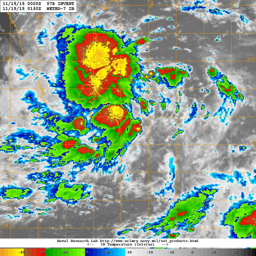
97B.INVEST over Southwest Bay of Bengal Location 7.2 N. & 82.5 E. 20 knots with 1007 millibar Central Pressure NRL IR Satellite Image
on 15th November @ 0130 UTC
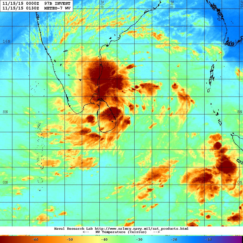
97B.INVEST over Southwest Bay of Bengal Location 7.2 N. & 82.5 E. 20 knots with 1007 millibar Central Pressure NRL Water Vapor Satellite Image
on 15th November @ 0130 UTC
Forecast: 15th to 20th November 2015
Heavy to very heavy & extremely heavy rainfall during the forecast period over Southern Peninsula which includes Tamil Nadu, Kerala, Karnataka & Andhra Pradesh. Maximum quantum of rainfall is expected over Coastal Tamilnadu & Southern Karnaka.
Wunderground Map showing System location on GFS 925 hPa
Forecast run 1800 UTC on 14th November 2015 valid 16th November 2015 @ 00 UTC

Wunderground Map showing System location on ECMWF 925 hPa
Forecast run 1200 UTC on 14th November 2015 valid 16th November 2015 @ 00 UTC

Forecast: Saurashtra, Gujarat & Kutch: 15th November to 20th November
Bay of Bengal System is expected to track over the Southern Peninsula and cross over to Arabian Sea around 18th November. No direct effect for Saurashtra, Gujarat & Kutch by the Bay of Bengal System during the forecast period. The weather is expected to be dry. The wind is expected to be from North or Northeast on most days till 18th and then could change to from East on 19th & 20th November.
અપડેટ 15 નવેમ્બર 2015 સવારે 8.00 કલાકે:
દક્ષીણ પશ્ચિમ બંગાળ ની ખાડી માં શ્રીલંકા નજીક વેલ માર્કડ લો પ્રેસર છે.
વેસ્ટર્ન ડીસ્ટર્બન્સ UAC તરીકે પૂર્વ અફઘાનિસ્તાન અને લાગુ પાકિસ્તાન ઉપર 3.1 કિમી ની ઉંચાયે છવાયેલ છે.
સૌરાષ્ટ્ર, કચ્છ અને ગુજરાત: 15 નવેમ્બર થી 20 નવેમ્બર 2015
બંગાળની ખાડી ની સીસ્ટમ તમિલનાડુ ઉપર થી પશ્ચિમ તરફ ગતિ કરી અને 18 તારીખ આસપાસ અરબી સમુદ્ર માં દાખલ થશે. તેમ છતાં આગાહી સમય માં સૌરાષ્ટ્ર, ગુજરાત અને કચ્છ ને અસર નહિ કરે.
મુખ્યત્વે વાતાવરણ સુકું અને મહત્તમ દિવસે પવન ઊત્તર અને ઊત્તર પૂર્વ તરફ થી ફૂંકાશે, જોકે આગાહી ના છેલ્લા બે એક દિવસ પવનો પૂર્વ બાજુ થી ફૂંકાશે.
Scroll Up