Current Weather Conditions on 6th November @ 8.00 am. IST
Observations:
The Cyclonic Storm “MEGH” is now over Westcentral Arabian Sea. As per International Weather Agencies the winds are blowing at 75 km./hour with gusts of 95 km/hour based on average winds on 1 minute basis as compared to IMD’s basis of 3 minute average wind speed. The System is expected to track towards Socotra Island, Yemen next few days. The System expected to strengthen further to a Severe Cyclonic Storm during the next 24 hours as per IMD/RSMC norms.
Under the influence of UAC over South Bay of Bengal a Low Pressure area has developed over Southeast Bay of Bengal. This System is being monitored as 96B.INVEST.
The Western Disturbance as an Upper Air Cyclonic Circulation over Jammu & Kashmir and adjoining North Pakistan extending up to 3.1 km above mean with a trough aloft roughly along Long. 72.0°E and North of Lat. 30.0°N persists. The induced UAC over Punjab & neighborhood extending up to 1.5 km above mean sea level also persists.
Another Western Disturbance would affect Western Himalayan region from 8th November.
TROPICAL CYCLONE ADVISORY RSMC – TROPICAL CYCLONES, NEW DELHI TROPICAL STORM ‘MEGH’ ADVISORY NO. FOUR ISSUED AT 0000 UTC OF 6 TH NOVEMBER 2015 BASED ON 2100 UTC CHARTS OF 5TH NOVEMBER 2015.
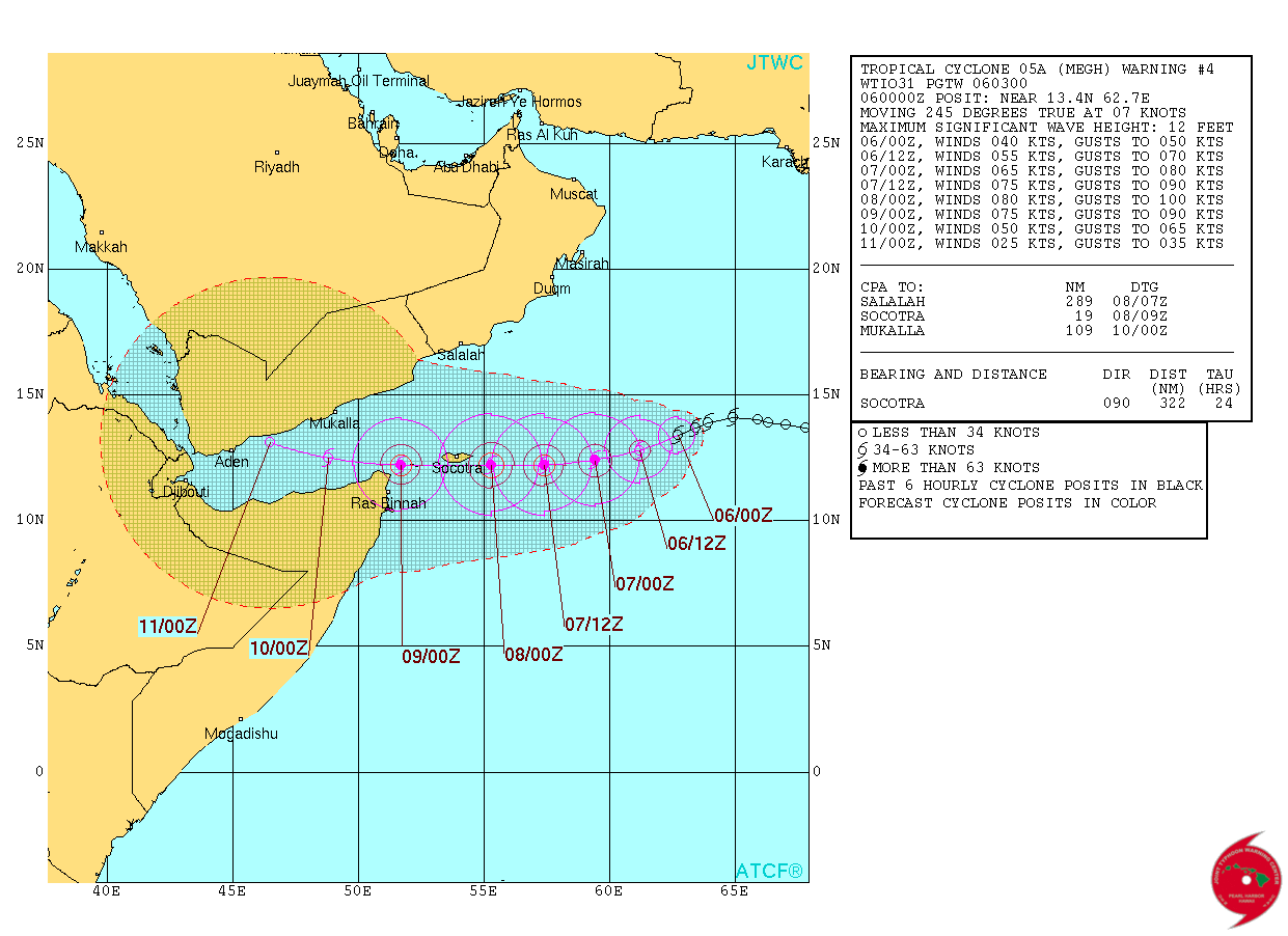
THE CYCLONIC STORM ‘MEGH’ OVER WESTCENTRAL ARABIAN SEA MOVED WESTSOUTHWESTWARDS AT A SPEED OF 11 KMPH IN PAST SIX HOURS AND LAY CENTRED AT 2100 UTC OF TODAY THE 5 TH NOVEMBER 2015 NEAR LATITUDE 13.8 0 N AND LONGITUDE 63.1 0 E, ABOUT 1190 KM SOUTHWEST OF MUMBAI (43003) AND 1040 KM EAST-SOUTHEAST OF SALALAH (41316), OMAN. IT WOULD MOVE WEST-SOUTHWESTWARDS AND INTENSIFY INTO A SEVERE CYCLONIC STORM DURING NEXT 24 HRS. IT WOULD CONTINUE TO MOVE WEST-SOUTHWESTWARDS TOWARDS GULF OF ADEN.
ACCORDING TO SATELLITE IMAGERY, INTENSITY IS T 2.5. MAXIMUM SUSTAINED SURFACE WIND SPEED IS 40 KNOTS GUSTING TO 50 KNOTS. THE ESTIMATED CENTRAL PRESSURE IS ABOUT 998 HPA. STATE OF SEA AROUND SYTEM CENTRE IS HIGH. ASSOCIATED BROKEN LOW AND MEDIUM CLOUDS WITH EMBEDDED MODERATE TO INTENSE CONVECTION OVER AREA BETWEEN LATITUDE 12.0 DEGREE NORTH TO 17.0 DEGREE NORTH AND LONGITUDE 61.0 DEGREE EAST TO 65.0 DEGREE EAST. MINIMUM CTT IS -72 0cC, THE CLOUD SHOWS CURVED BAND PATTERN.
JTWC Tropical Cyclone 05A (Five) Warning #04
on 6th Nov. 2015 @ 0300 UTC
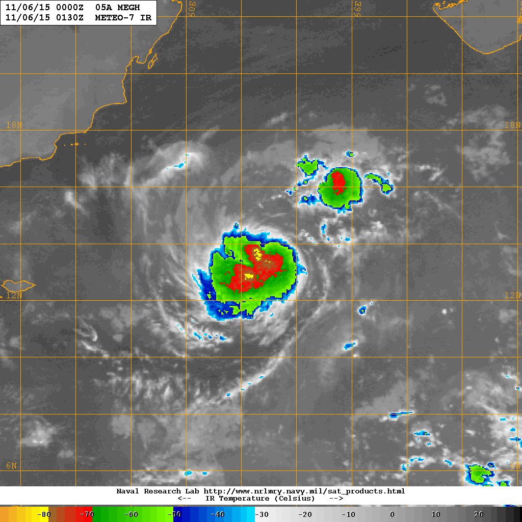
05A.MEGH Now Over Central Arabian Sea Location 13.4 N. & 62.7 E. with winds of 40 knots with 993 millibar Central Pressure on 6th November NRL IR Satellite Image @ 0130 UTC
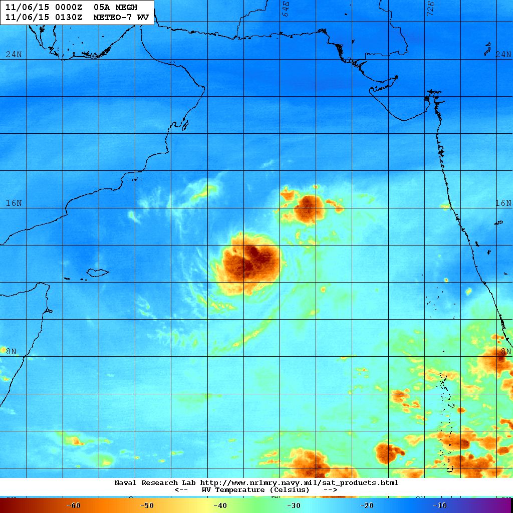
05A.MEGH Now Over Central Arabian Sea Location 13.4 N. & 62.7 E. with winds of 40 knots with 993 millibar Central Pressure on 6th November NRL Water Vapor Satellite Image @ 0130 UTC
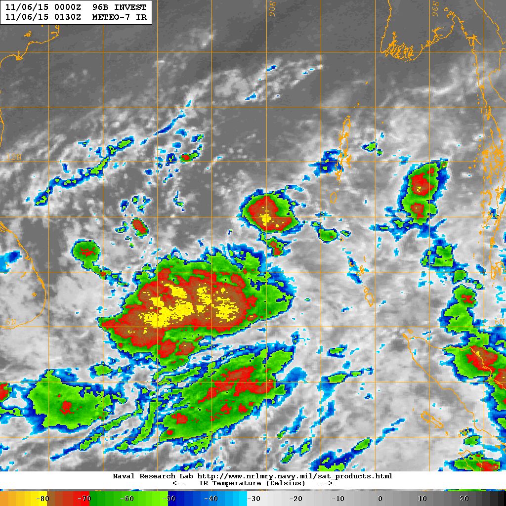
96B.INVEST Over Southeast Bay of Bengal Location 8.7 N. & 89.5 E. with winds of 20 knots with 1007 millibar Central Pressure on 6th November NRL IR Satellite Image @ 0130 UTC
Forecast for Saurashtra, Gujarat & Kutch: 6th to 12th November 2015
Cyclonic Storm “MEGH” will not affect Saurashtra, Gujarat & Kutch since the System is tracking Westwards away from India.
Forecast models indicates that the Bay of Bengal System is expected to cross over to the Arabian Sea and is not expected to affect Saurashtra, Gujarat & Kutch during the forecast period.
The Maximum and Minimum Temperature over most parts of Saurashtra, Gujarat & Kutch will be normal or slightly above normal. The weather is expected to be dry with winds mainly from North/Northeast during the forecast period.
Advance Indications: If the Bay of Bengal System (96B.INVEST ) crosses over to Arabian Sea, there is 50% chance of unseasonal rain over Saurashtra, Gujarat & Kutch after the end of current forecast period (meaning after 12th November).
Caution:
Please refer/rely on IMD/RSMC Bulletins/Advisories for Storms & Weather related matter.
અપડેટ તારીખ 6 નવેમ્બર 2015 સવારે 8.00 કલાકે:
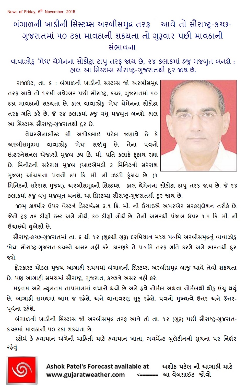
અરબી સમુદ્ર માં જે વાવાઝોડું “MEGH” છે તેના પવનો ઇન્ટરનેસનલ એજન્સી મૂજબ 75 કિમી પ્રતિ કલાકે ફૂંકાય છે (1 મિનીટ ની શરેરાશ મૂજબ ) જે IMD 3 મિનીટ ની શરેરાશ મૂજબ માપે છે. આંચકા ના પવનો 95 કિમી ની ઝડપે ફૂંકાય છે (1 મિનીટ ની શરેરાશ મૂજબ ). અરબી સમુદ્ર ની સીસ્ટમ હાલ યેમેન ના સોકોટ્રા ટાપુ તરફ તરફ જાય છે અને 24 કલાક માં હજુ મજબૂત થશે. સીસ્ટમ સૌરાષ્ટ્ર તેમજ ગુજરાત થી દૂર જાય છે.
દક્ષીણ બંગાળી ખાડી માં UAC હતું તેની અસર થી દક્ષીણ પૂર્વ બંગાળ ની ખાડી માં લો પ્રેસર થયું છે.
જમ્મુ કાશ્મીર ઉપર વેસ્ટર્ન ડીસ્ટર્બન્સ 3.1 કિમી ની ઉંચાયે UAC તરીકે છે જેનો ટ્રફ 72.0°E and North of Lat. 30.0°N. છે. એની અસર થી પંજાબ ઉપર 1.5 કિમી ની ઊંચાયે UAC થયું.
તારીખ 8 નવેમ્બર ના નવું વેસ્ટર્ન ડીસ્ટર્બન્સ પશ્ચિમ હિમાલય માં છવાશે.
સૌરાષ્ટ્ર, કચ્છ અને ગુજરાત: 6 નવેમ્બર થી 12 નવેમ્બર 2015
મધ્ય પશ્ચિમ અરબી સમુદ્ર નું વાવાઝોડું “મેઘ” સૌરાષ્ટ્ર, ગુજરાત અને કચ્છ ને અસર નહિ કરે કારણ કે તે પશ્ચિમ તરફ ગતિ કરશે અને ભારત થી દૂર જશે.
ફોરકાસ્ટ મોડલ મૂજબ આગાહી સમય માં બંગાળની સીસ્ટમ અરબી સમુદ્ર બાજુ આવે તેવી શક્યતા છે પણ આગાહી સમય માં સૌરાષ્ટ્ર, ગુજરાત અને કચ્છ ને અસર નહિ કરે.
મહત્તમ અને ન્યુનત્તમ તાપમાન માં વધારો થયો છે અને હવે નોર્મલ અથવા નોર્મલ થી થોડું ઊંચું થયું છે. આગાહી સમય માં આમજ રહેશે અને વાતાવરણ સુકું રહેશે તેમજ પવનો મુખ્યત્વે ઊત્તર અને ઊત્તર પૂર્વ ના રહેશે.
આગોતરું એંધાણ: બંગાળની ખાડી ની સીસ્ટમ જો અરબી સમુદ્ર બાજુ આવે તો તારીખ 12 પછી સૌરાષ્ટ્ર, ગુજરાત અને કચ્છ માં માવઠા ની 50% શક્યતા ગણવી.
સાવચેતી:
સ્ટોર્મ કે હવામાન અંગે ની માહિતી માટે ભારતીય હવામાન ખાતા/ગવર્મેન્ટ ના બુલેટીન/સુચના પર નિર્ભર રહેવું.
Weather Forecasat in Akila Daily Dated 6th November 2015
Note: minor editions done for clarity.
Scroll Up