Update: 4th November 9.00 am. IST.
The Low Pressure over the Eastcentral Arabian Sea is now Well Marked.
Current Weather Conditions on 4th November 2015 @ 7.30 am. IST
Under the influence of an Upper Air Cyclonic Circulation over Eastcentral Arabian Sea off Karnataka coast, a Low Pressure area has formed over Eastcentral & adjoining Southeast Arabian Sea. Associated Upper Air Cyclonic Circulation extends up to 3.1 km above mean sea level. The system is expected to become Well Marked Low Pressure area during next 24 hours.
There is a Western Disturbance as an Upper Air Cyclonic Circulation over North Pakistan & neighborhood extending up to 3.1 km above mean sea level.
There is also another Western Disturbance as an Upper Air Trough in Mid-Tropospheric Westerlies roughly along Long. 53.0°E and North of Lat. 30.0°N. Under its influence an induced Upper Air Cyclonic Circulation likely to form over Central Pakistan & neighborhood within 24 hours.
Forecast: 4th to 10th November 2015
The Low Pressure over the Eastcentral Arabian Sea is expected to track mainly Westwards during the next five days and so will move away from the Indian Coast. This System is being monitored as 95A.INVEST
A fresh UAC/Low Pressure will Develop over the South Bay of Bengal during the next few days.
The Western Disturbance will give heavy snowfall for Jammu & Kashmir and hilly regions of North India and rain for the plains of North Indian States on 4th & 5th November.
95A.INVEST over Eastcentral Arabian Sea Location 13.0 N. & 67.4 E. 20 knots with 1007 millibar Central Pressure NRL IR Satellite Image on 4th November @ 0130 UTC

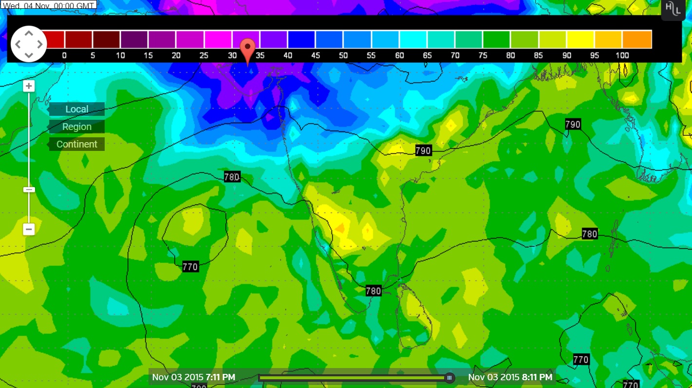
Wunderground Map showing System location on GFS 925 hPa
Latest Forecast run valid 4th November 2015 @ 00 UTC
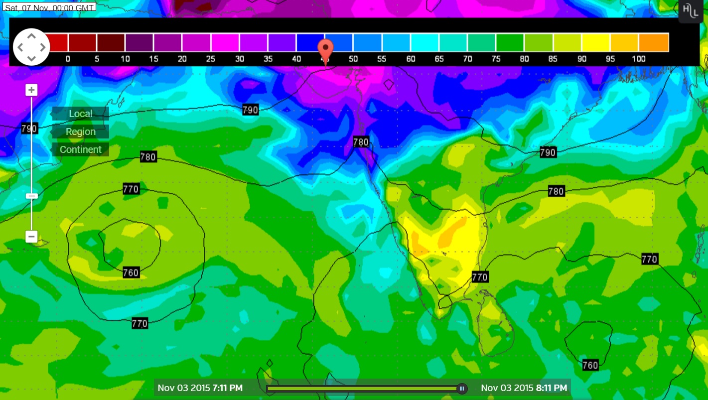
Wunderground Map showing System location on GFS 925 hPa
Latest Forecast run valid 7th November 2015 @ 00 UTC
Forecast: Saurashtra, Gujarat & Kutch: 4th to 10th November 2015
There will not be any direct effect from the Arabian Sea Low Pressure since it is expected to track Westwards away from the Indian Coast. The Maximum and Minimum Temperature over most parts of Saurashtra, Gujarat & Kutch has increased again and have become normal or been above normal at some places. The Temperature is expected to remain normal or above normal over most places. The weather is expected to be dry during the forecast period.
અપડેટ 4 નવેમ્બર સવારે 9.00 કલાકે: મધ્યપૂર્વ અરબી સમુદ્ર નું લો પ્રેસર હવે મજબૂત બની વેલ માર્કડ લો પ્રેસર થયું.
અપડેટ 4 નવેમ્બર 2015 સવારે 7.30 કલાકે:
મધ્ય પૂર્વ અરબી સમુદ્ર માં UAC ની અસર થી લો પ્રેસર થયું છે.
એક વેસ્ટર્ન ડીસ્ટર્બન્સ ઉત્તર પાકિસ્તાન અને આસપાસ ના વિસ્તાર માં છે.
બીજું વેસ્ટર્ન ડીસ્ટર્બન્સ અપર એર ટ્રફ ની વેસ્ટરલી તરીકે 53.0°E and North of Lat. 30.0°N. છે. તેની અસર થી સેન્ટ્રલ પાકિસ્તાન અને આસપાસ ના વિસ્તાર ઉપર 24 કલાક માં UAC થશે.
આગાહી : 4 થી નવેમ્બર થી 10 નવેમ્બર 2015
વેસ્ટર્ન ડીસ્ટર્બન્સ ની અસર થી આજે અને આવતી કાલે જમ્મુ અને કાશ્મીર અને ઊત્તર ભારત ના પહાડી વિસ્તારો માં હિમ વર્ષા તેમજ મેદાની વિસ્તારો માં વરસાદ થશે.
મધ્ય પૂર્વ અરબી સમુદ્ર વાળું લો પ્રેસર હજુ મજબૂત થશે અને પશ્ચિમ તરફ ગતિ કરશે, જે ભારત થી દૂર જશે.
દક્ષીણ બંગાળ ની ખાડી માં થોડા દિવસ માં એક નવું UAC /લો પ્રેસર થશે.
સૌરાષ્ટ્ર, કચ્છ અને ગુજરાત: 4 થી નવેમ્બર થી 10 નવેમ્બર 2015
મધ્ય પૂર્વ અરબી સમુદ્ર નું લો પ્રેસર સૌરાષ્ટ્ર, ગુજરાત અને કચ્છ ને અસર નહિ કરે કારણ કે તે પશ્ચિમ તરફ ગતિ કરશે અને ભારત થી દૂર જશે.
મહત્તમ અને ન્યુનત્તમ તાપમાન માં વધારો થયો છે અને હવે નોર્મલ અથવા નોર્મલ થી થોડું ઊંચું થયું છે. આગાહી સમય માં આમ રહેશે વાતાવરણ સુકું રહેશે અને પવનો મુખ્યત્વે ઊત્તર અને ઊત્તર પૂર્વ ના રહેશે.
Scroll Up