Current Weather Conditions on 17th August 2015 @ 6.30 am. IST
Last Night Conditions:
The Low Pressure From East M.P. System has fizzled out 15th/16 and is now only a Upper Air Cyclonic Circulation which is now over East Uttar Pradesh & adjoining Bihar extending upto 1.5 km above mean sea level.
The Axis of Monsoon trough passes through Ferozepur, Karnal, Hardoi, Sultanpur, Gaya, Berhampore and thence Eastwards to Manipur across Assam. Another branch of Monsoon trough passes through Gaya, Purulia, Haldia and thence South Eastwards to Northeast Bay of Bengal.
The Western Disturbance as an Upper Air trough in Mid-Tropospheric Westerlies roughly along Longitude 70.0°E and North of Latitude 32.0°N persists.
The Upper Air Cyclonic Circulation over Haryana & adjoining Rajasthan extending upto 1.5 km above mean sea level persists.
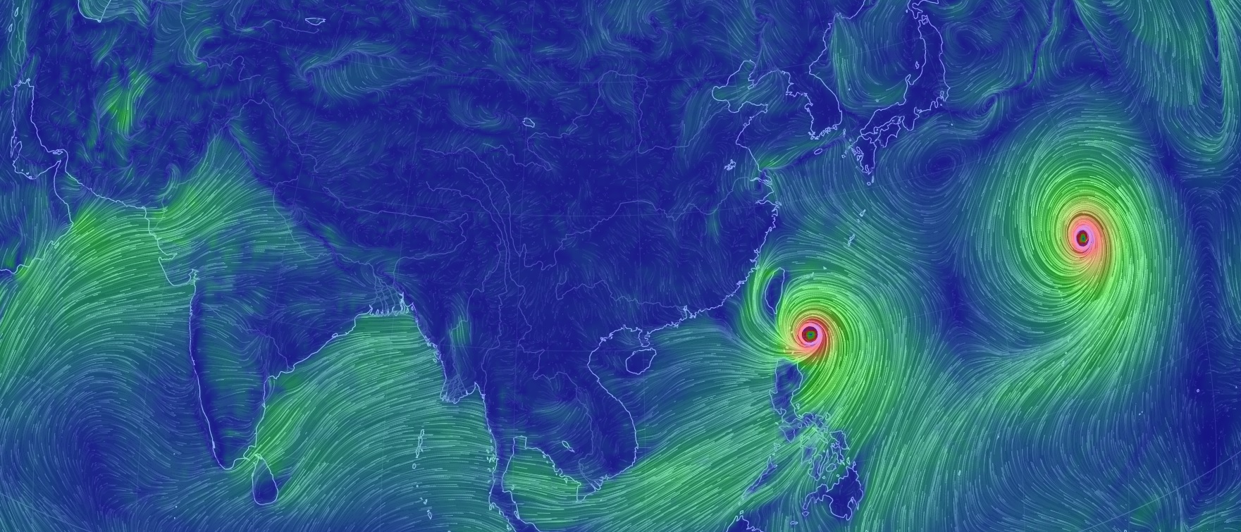
There are two Systems (Cyclones) in the West Pacific, Typhoon GONI & Typhoon ATSANI. Both these Systems are forecast to attain 120 knots (about 220 Kms./hour) wind speed around 19th/20th August 2015.
Nullschool Wind Forecast Chart at 2100 UTC on 20th August 2015 Showing Typhoon GONI & Typhoon ATSANI
Forecast: 17th August to 22nd August 2015
Saurashtra, Kutch & Gujarat
There was a round of scattered rainfall over Saurashtra & South Gujarat and a better round of scattered rainfall over North Gujarat & East Central Gujarat during the last few days. Today is the last day of this round of rainfall. Very few places in Kutch got some light rain.
No meaningful rainfall for Gujarat from 18th to 22nd August but only scattered showers or drizzle for some pockets of Saurashtra, Kutch & Gujarat. Wind speed will increase around 19th/20th August over Kutch and adjoining areas of Saurashtra.
તારીખ 17 ઓગસ્ટ સવારે 6.30 વાગ્યે
લો પ્રેસર ખતમ થયું પણ UAC હજુ છે જે બિહાર અને પૂર્વ યુપી આસપાસ છે
ચોમાસું ધરી પંજાબ થી યુપી અને બિહાર બાજુ અને બિહાર થી એક છેડો આસામ બાજુ જાય છે અને બિહાર થી બીજો છેડો હલ્દિયા અને ત્યાં થી ઊત્તર પૂર્વ બંગાળની ખાડી તરફ જાય છે.
પશ્ચિમ પ્રશાંત મહાસાગર માં બે વાવાઝોડા છે જેને તે વિસ્તાર માં ટાયફૂન કહે છે. એક છે ટાયફૂન ગોની અને બીજો છે ટાયફૂન અટસાની. તારીખ 19/20 આસપાસ બંને ટાયફૂન ની પવન ની ઝડપ 220 કિમી થી વધુ થશે.
સૌરાષ્ટ્ર કચ્છ ગુજરાત:
તારીખ 17 ઓગસ્ટ થી 22 ઓગસ્ટ 2015
આ રાઉન્ડ માં સૌરાષ્ટ્ર અને દક્ષીણ ગુજરાત માં છૂટો છવાયો હળવો મધ્યમ વરસાદ થયો અને ઊત્તર ગુજરાત અને મધ્ય પૂર્વ ગુજરાત માં તેનાથી વધુ પ્રમાણ માં વરસાદ થયો જોકે છૂટો છવાયો હતો. કચ્છ બાજુ એકલ દોકલ જગ્યાએ હળવો વરસાદ થયો. આ વરસાદ નો રાઉન્ડ આજનો દિવસ છે.
તારીખ 18 થી 22 દરમ્યાન અંશત વાદળ છાયું વાતાવરણ. જૂજ વિસ્તાર માં છુટ્ટા છવાયા ઝાપટા. હાલ કોઈ મોટો વરસાદ નથી. તારીખ 19/20 ઓગસ્ટ આસપાસ કચ્છ અને લાગુ સૌરાષ્ટ્ર ના વિસ્તાર માં પવન ની ઝડપ વધશે. પવન વધી ને આશરે 30 થી 40 કિમી થશે.

Scroll Up