Posted on 12th October 2014 @ 8.00 am.
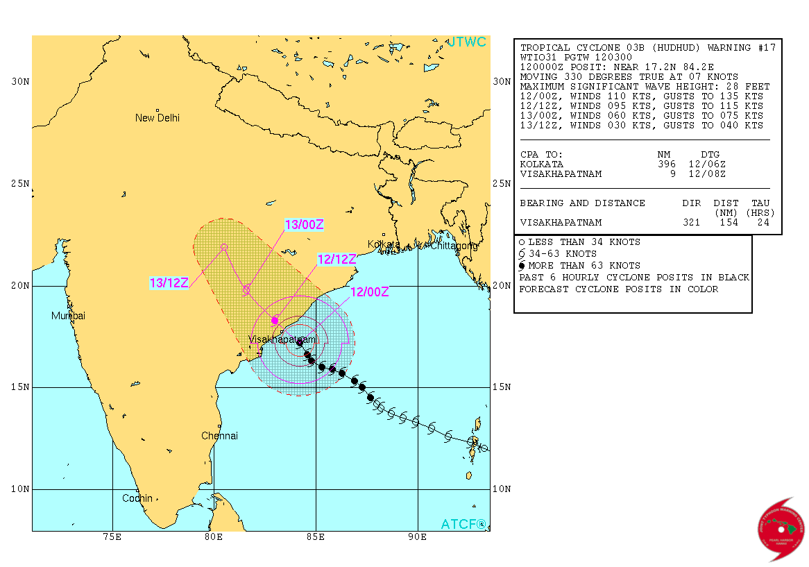
JTWC has isssued Tropical Cyclone Warning Number 17 @ 0300 UTC on 12-10-2014 for conditions at 0000 UTC of 12-10-2014. System 03B.Hudhud had 110 knots wind speed with 941 mb. Central Pressure located at Lat. 17.2°N & Long. 84.2°E over the West Central Bay of Bengal. System has Tracked at 7 knots during the last six hours.
1 knot wind speed = 1.852 Kms./Hour wind speed.
System was 100 kms. Southeast from Visakhapatnam @ 0200 UTC (at 7.30 am. IST ) on 12th October 2014.
JTWC Tropical Cyclone 03B.HUDHUD Warning No. 17
Tropical Cyclone Forecast Track
Please read the IMD National Bulletin & RSMC Bulletin first.
IMD National Bulletin available here
RSMC Bulletin available here
From IMD Bulletin issued at 0500 IST today
Warning for North Andhra Pradesh and South Odisha
(i) Heavy rainfall warning: Under the influence of the system, rainfall at most places with heavy (6.5–12.4 cm) to very heavy falls (12.5–24.4 cm) at a few places and isolated extremely heavy falls (≥ 24.5 cm) would occur over west & east Godavari, Visakhapatnam, Vijayanagaram & Srikakulam districts of north Andhra Pradesh and Ganjam, Gajapati, Koraput, Rayagada, Nabarangpur, Malkangiri, Kalahandi,
Phulbani districts of south Odisha during next 48 hrs. Rainfall would occur at most places with heavy to very heavy rainfall at isolated places over Krishna, Guntur & Prakasham districts of Andhra Pradesh and north coastal Odisha during the same period.
(ii) Wind warning: Wind speed reaching 70-80 kmph gusting to 90 kmph would prevail along & off north Andhra Pradesh and south Odisha coasts during next 06 hours. The wind speed would gradually increase to 170-180 kmph gusting to 195 kmph around the time of landfall along & off north Andhra Pradesh (East Godavari, Visakhapatnam, Vizianagaram and Srikakulam districts) and 80-90 kmph along and off adjoining districts of Andhra Pradesh (West Godavari & Krishna districts) and south Odisha (Ganjam, Gajapati, Koraput and Malkangiri districts).
(iii) Sea condition along and off north Andhra Pradesh and south Odisha coasts: Sea condition would be rough to very rough during next few hours. It would gradually become phenomenal from today, the 12th morning onwards along & off north Andhra Pradesh coast and very rough to high along & off south Odisha and south Andhra Pradesh coast during next 24 hours.
(iv) Storm surge warning: Storm surge of about 1-2 meters above astronomical tide would inundate low lying areas of Visakhapatnam, Vijayanagaram and Srikakulam districts of north coastal Andhra Pradesh at the time of landfall.
(v) Damage expected:
A) North Andhra Pradesh (East Godavari, Visakhapatnam, Vizianagaram and Srikakulam districts): Under the influence of system, extensive damage to kutcha houses. Some damage to old buildings. Large scale disruption of power and communication lines. Disruption of rail and road traffic due to extensive flooding. Potential threat from flying debris. Damage to agricultural crops.
B) West Godavari & Krishna districts of Andhra Pradesh and south Odisha coasts (Ganjam, Gajapati, Koraput and Malkangiri districts): Damage to thatched huts. Breaking of tree branches causing minor damage to power and communication lines. Uprooting of small trees. Damage to agricultural crops.
(vi) Action suggested:
A) North Andhra Pradesh (East Godavari, Visakhapatnam, Vizianagaram and Srikakulam districts): Total suspension of fishing operations in area of influence of cyclone. Mobilise extensive evacuation from coastal areas. Diversion or suspension of aviation, navigation, rail and road traffic. People in affected areas to remain at safe places around landfall period.
B) West Godavari & Krishna districts of Andhra Pradesh and south Odisha coasts (Ganjam, Gajapati, Koraput and Malkangiri districts): Total suspension of fishing operations. People in affected areas to remain at safe places. Post landfall outlook: Even after landfall the system would maintain the intensity of very severe cyclonic storm for 6 hours and gradually weaken into a cyclonic storm in subsequent 6 hours while moving northwestwards across south interior Odisha and Chattisgarh. Under its influence rainfall at most places with heavy falls at a few places would occur over south Chattisgarh, adjoining Telangana and south Odisha and isolated heavy to very heavy falls over north Chattisgarh and north Odisha. Gale wind speed reaching 100-120 kmph gusting to 130 kmph would also prevail for 6 hours after landfall and 80-90 kmph gusting to 100 kmph for subsequent 6 hours over East Godavari, Visakhapatnam, Vizianagaram and Srikakulam districts of north Andhra Pradesh and Ganjam, Gajapati, Koraput and Malkangiri districts of Odisha during the same period. Squally winds speed reaching 55-65 kmph gusting to 75 kmph would also prevail for next 12 hours after landfall over south Chattisgarh and adjoining districts of north Telangana and south Odisha.
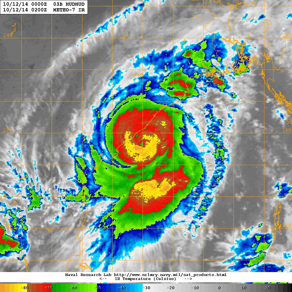
NRL IR Satellite Image of TC 03B.HUDHUD
( Very Severe Cyclonic Storm “HUDHUD” )
on 12th October 2014 @ 0200 UTC (7.30 am. IST )
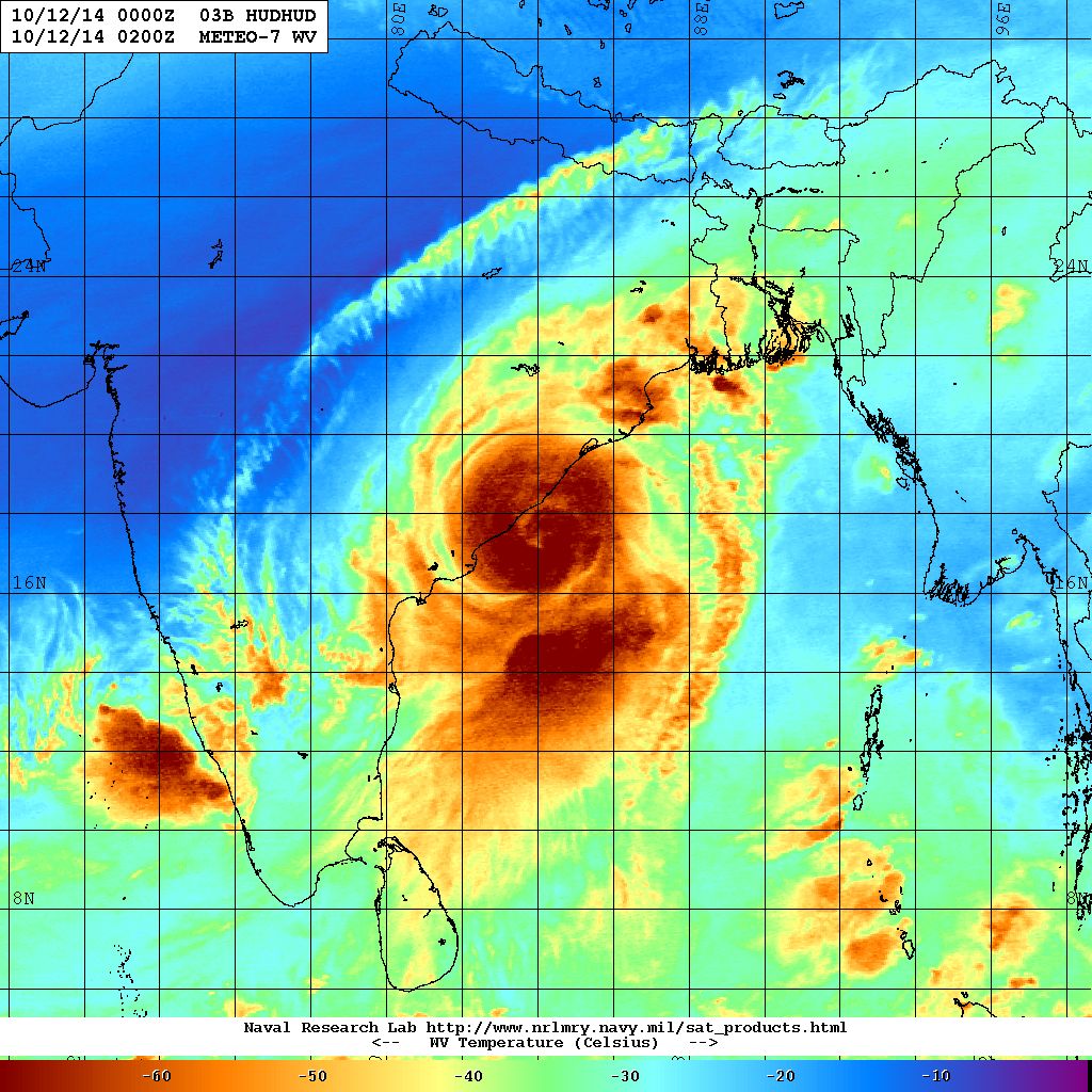
NRL Water Vapor Satellite Image of TC 03B.HUDHUD
( Very Severe Cyclonic Storm “HUDHUD” )
on 12th October 2014 @ 0200 UTC (7.30 am. IST )
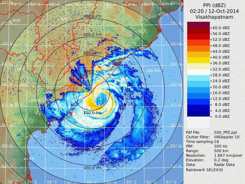
Doppler Product For Visakhapatnam
Forecast: 12th October to 14th October 2014
Very Severe Cyclonic Storm “HUDHUD” – TC 03B.HUDHUD :
Very Severe Cyclonic Storm “HUDHUD” is expected to make landfall near Visakhapatnam over North Andhra Pradesh coast near Visakhapatnam today around 0900 UTC ( 2.30 pm.IST ).
Note: Refer/Rely on IMD/RSMC Bulletins/Advisories