Current Weather Conditions on 10th October 2014 @ 8.00 am.
JTWC has isssued Tropical Cyclone Warning Number 9 @ 0300 UTC on 10-10-2014 for conditions at 0000 UTC of 10-10-2014. System 03B.Hudhud had 65 knots wind speed with 974 mb. Central Pressure located at Lat. 14.4°N & Long. 87.6°E over the Central Bay of Bengal.
1 knot wind speed = 1.85 Kms./Hour wind speed.
JTWC Tropical Cyclone 03B.HUDHUD Warning No. 9
Tropical Cyclone Forecast Track
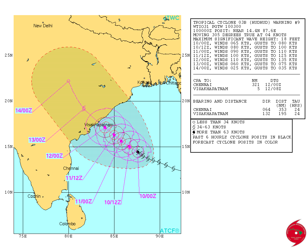
Warning for north Andhra Pradesh coast and south Odisha
(i) Heavy rainfall warning: Under the influence of the system, rainfall at most places with heavy (6.5 – 12.4 cm) to very heavy falls (12.5 – 24.4 cm) at a few places and isolated extremely heavy falls (≥ 24.5 cm) would occur over east Godavari, Visakhapatnam, Vijayanagaram and Srikakulam districts of north coastal Andhra Pradesh and south Odisha from 11th evening onwards. Rainfall would occur at most places with heavy to very heavy rainfall at isolated places over remaining districts of Andhra Pradesh and north coastal Odisha during the same period.
(ii) Wind warning: Squally wind speed reaching 50-60 kmph gusting to 70 kmph would commence along and off north Andhra Pradesh and south Odisha coasts from 11th morning onwards. The wind speed would increase to 130-140 kmph gusting to 155 kmph from 12th morning along and off north Andhra coast and 80-90 kmph along and off south Odisha coast.
(iii) Sea condition along and off north Andhra Pradesh and south Odisha coasts: Sea
condition would be rough to very rough from 11th morning. It would gradually become phenomenal from 12th morning onwards along and off north Andhra coast and very rough to high along and off south Odisha coast.
(iv) Storm surge warning: Storm surge of about 1-2 meters above astronomical tide would inundate low lying areas of east Godavari, Visakhapatnam, Vijayanagaram and Srikakulam districts of north coastal Andhra Pradesh at the time of landfall.
(v) Damage expected: Under the influence of system, extensive damage to kutcha houses. Partial disruption of power and communication lines. Minor disruption of rail and road traffic. Potential threat from flying debris. Flooding of escape routes.
(vi) Action suggested: Suspension of fishing operations in area of influence of cyclone. Judicious regulation of aviation, navigation, rail and road traffic. People in affected areas to remain at safe places around landfall period.
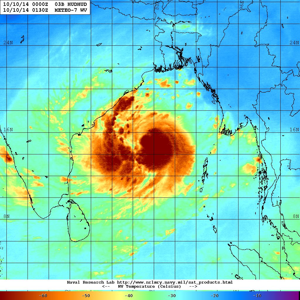
NRL Water Vapor Satellite Image of 03B.HUDHUD
( Severe Cyclonic Storm “HUDHUD” )
on 10th October 2014 @ 01.30 UTC (8.00 am. IST )
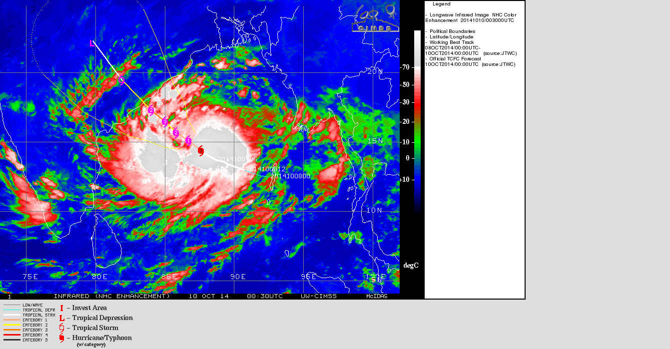
UW-CIMMS IR Satellite Image of 03B.HUDHUD
( Severe Cyclonic Storm “HUDHUD”)
on 10th October 2014 @ 00.30 UTC (6.00 am. IST )
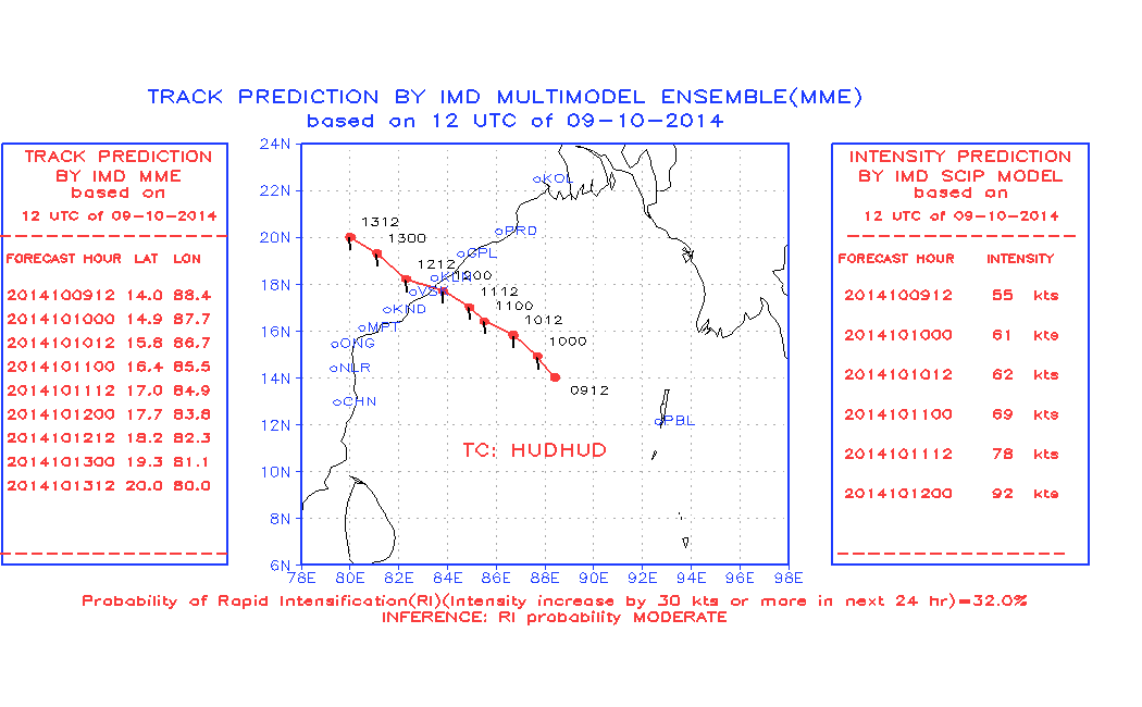
Forecast track by IMD Multimodel Ensemble (MME) Valid 12.00 UTC of 9-10-2014
For NWP Tropical Cyclone Genesis Potential Animation Track of the current System Click here
Forecast: 10th October to 14th October 2014
Severe Cyclonic Storm “HUDHUD” – 03B.HUDHUD :
Severe Cyclonic Storm “HUDHUD” is expected to track mainly West Northwest for next six hours and then Northwesterly direction towards North Andhra Pradesh/South Odisha Coast for next two days. The System is expected to strengthen further to Very Sever Cyclonic Storm within next 12 hours. Landfall expected around 12th October vicinity of Vishakhapatnam as per both GSF as well as ECMWF available forecast runs.
Note: Refer/Rely on IMD/RSMC Bulletins/Advisories
તારીખ ૧૦ ઓક્ટોબર ૨૦૧૪ :
બંગાળની ખાડી માં તીવ્ર વાવાઝોડું આજે સવારે ૫.૩૦ કલાક IST Lat. 14.4 N & Long. 87.6 E. એ હતું અને તેના કેન્દ્ર માં પ્રેસર 974 મિલીબાર હતું તેમજ પવન ૧૨૦ કિમી પ્રતિ કલાકે ( ૧ મિનીટ ની શરેરાશ મૂજબ પવન ની ઝડપ ) હતી. આ વાવાઝોડા ના કેન્દ્ર પાસે દરિયા ના મોજા ૨૦ ફૂટ ઊંચા ઊછળતા હતા. આ વાવાઝોડું પશ્ચિમ ઊત્તર પશ્ચિમ તરફ આગળ વધે છે તેમજ ત્યાર બાદ ઊત્તર પશ્ચિમ તરફ આગળ વધશે. તારીખ ૧૨ ના ઊત્તર આંધ્ર અને દક્ષીણ ઓડીશા ના દરિયા કિનારે ત્રાટકશે.
૧૨ થી ૨૪ કલાક માં આ વાવાઝોડું “હડહડ” મજબૂત બની અતિ ત્રીવ વાવાઝોડામાં પરિવર્તિત થશે.
આ વાવાઝોડા થી આંધ્ર પ્રદેશ, ઓડીશા, છાતીશ્ગઢ, વિદર્ભ એમ પી યુપી માં વરસાદ થશે જે કાંઠા ના વિસ્તાર માં ભારે થી અતિ ભારે માત્રા રહેશે.
સૌરાષ્ટ્ર, ગુજરાત અને કચ્છ:
તારીખ ૧૦ થી ૧૪ દરમિયાન મુખ્યત્વે વતાવરણ સૂકું રહેશે. બંગાળની ખાડી ના વાવાઝોડું ની અસર ખાસ નહિ થાય . ફક્ત ક્યારેક વાવાઝોડાના વાદળ સમૂહો ની પૂંછડી ગુજરાત ઉપર પસાર થઇ શકે.
Scroll Up