Current Weather Conditions on 7th October 2014 @ 7.00 am.
The thunder activity over Saurashtra & Gujarat has decreased during the last few days. However, there is an Upper Air instability over some parts of Saurashtra & Gujarat. The Maximum and Minimum Temperature over most parts of Saurashtra, Gujarat & Kutch has been 1 to 2 Degrees above normal for this time of the year.
The Western Disturbance as an Upper Air System would affect Western Himalayan region from today onwards.
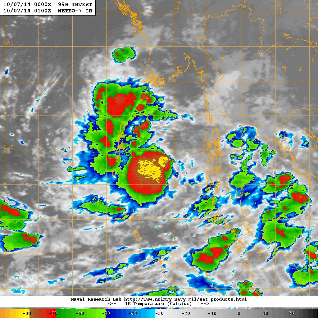
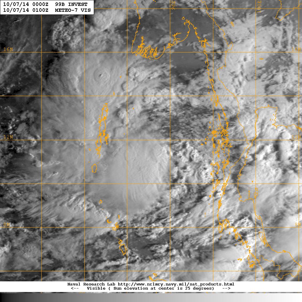
The Low Pressure over North Andaman Sea has Strengthened to a Well Marked Low Pressure. NRL has this System as 99B.INVEST location was Lat. 11.5°N & Long. 95.1°E with 25 knots wind speed and 1004 mb. Pressure and tracking at 4 knots.
NRL IR Satellite Image of 99B.INVEST (Well Marked Low Pressure)
on 7th October 2014 @ 01.00 UTC (6.30 am. IST )
NRL Visible Satellite Image of 99B.INVEST (Low Pressure)
on 7th October 2014 @ 01.00 UTC (6.30 am. IST )
Forecast: 7th October to 12th October 2014
Due to an Upper Air instability over some parts of Saurashtra & Gujarat there is a possibility of unseasonal thunder showers over parts of Saurashtra today & tomorrow. Weather expected to remain dry for the rest of the forecast period. The Maximum Temperature over Saurashtra & Gujarat is expected to remain higher than normal and could increase by 1 to 2 Degrees during the forecast period thereby making it 2 to 3 C above normal for this time of the year.
Well Marked Low Pressure – 99B.INVEST:
The Well Marked Low Pressure area over the North Andaman Sea is expected to strengthen further into a Depression during the next 24 hours as it tracks towards North Andaman Islands.
For NWP Tropical Cyclone Genesis Potential Animation of the current System Click here
Note: Refer/Rely on IMD/RSMC Bulletins/Advisories
તારીખ ૭ ઓક્ટોબર ૨૦૧૪:
સૌરાષ્ટ્ર અને ગુજરાત માં થોડા દિવસ થયા ઠંડર એક્ટીવીટી ઓછી થઇ છે. જોકે સૌરાષ્ટ્ર અને ગુજરાત ના ઘણા ભાગ માં ઉપલા લેવલે વાતાવરણ ની અસ્થિરતા છે. મહતમ તેમજ ન્યુનતમ તાપમાન નોર્મલ થી એક બે ડીગ્રી ઊંચું રહે છે.
ઊત્તર ભારત માં આજ થી વેસ્ટર્ન ડિસ્ટર્બંન્સ ની અસર જોવા મળશે.
ગઈ કાલે ઉદ્ભવેલ લો પ્રેસર મજબૂત બની વેલ માર્કડ લો તરિખે હાલ નોર્થ આંદામાન સી માં છવાયેલ છે.
આગાહી: તારીખ ૭ થી ૧૨ ઓક્ટોબર ૨૦૧૪
સૌરાષ્ટ્ર ના અમૂક ભાગ માં ઉપલા લેવલે અસ્થિરતા ને હિસાબે આજે અને કાલે માવઠા રૂપી ઠંડર એક્ટીવીટી ની શક્યતા છે. બાકી ના વિસ્તાર માં તથા સમય ગાળામાં વાતાવરણ મુખ્યત્વે સૂકું રહેશે. મહત્તમ તાપમાન માં હજુ એક થી બે ડીગ્રી નો વધારો આગાહી ના સમય ગાળા માં થશે. એટલે કે સામાન્ય મહત્તમ તાપમાન થી ૨ થી ૩ ડીગ્રી ઊંચું આગાહી ના પાછલા દિવસો માં જોવા મળશે.
વેલ માર્કડ લો પ્રેસર:
આ સીસ્ટમ ૨૪ કલાક માં હજુ મજબૂત બની ડીપ્રેસન માં પરિવર્તિત થશે તેમજ અંદામાન ટાપૂ નજીક પોંચશે. દર એક બે દિવસે અપડેટ આપવામાં આવશે.
Scroll Up