Current Weather Conditions on 3rd July 5.00 pm.
After an early onset of Southwest Monsoon over the Southern Coastal Saurashtra and South Gujarat on 15th June, there has not been any progress for Monsoon over rest of Saurashtra, Gujarat and whole of Kutch. Yesterday there was 24 mm. rainfall in Keshod of Junagadh District. In south Gujarat rainfall has been reported from Valsad District where average District rainfall was 26 mm. yesterday with Khergam getting highest of 69 mm. rainfall. Navsari District average rainfall yesterday was 25 mm. with highest in Dharampur 45 mm. Scattered showers were reported in Tapi & Surat Districts yesterday.
IMD Map showing the Progress of Southwest Monsoon Till 3rd July 2014
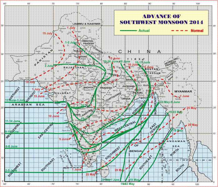
The Arabian branch of Southwest Monsoon has not moved ahead since 15th June.
The Southwest Monsoon has further advanced into some more parts of Uttar Pradesh, remaining parts of Haryana (including Delhi) and Punjab and some parts of north Rajasthan.
The Northern Limit of Monsoon (NLM) passes through Lat. 21°N / Long. 60°E,Lat.21°N / Long. 65°E, Veraval, Surat, Nashik, Washim, Damoh, Lucknow,Aligarh, Bikaner and Lat.28°N / Long. 72°E.
Also conditions are favourable for further advance of Southwest Monsoon in to remaining parts of Uttar Pradesh and some more parts of Rajasthan and Madhya Pradesh during next 3 days.
The Low Pressure area over Gangetic West Bengal and adjoining Bangla Desh now lies over Gangetic West Bengal and neighborhood. Associated Cyclonic Circulation extends up to 7.6 kms. above sea level.
The trough at mean sea level now runs from Punjab to North Bay of Bengal across Haryana, Uttar Pradesh, Jharkhand and the center of Low Pressure area.
The above clearly suggests that the Southwest Monsoon is yet active along the Foothills of the Himalayas. The 925 Mb. charts also suggests that the Easterly winds are restricted to the Himalayas only.
Forecast: 3rd July to 8th July 2014
Cloudy weather would prevail on most days of the forecast period. Wind speed is expected to decrease between 4th to 6th July and again pick up speed on 7th & 8th July.
Saurashtra: 3rd July to 8th July 2014
Current estimate of rainfall over Saurashtra during the forecast period is 10 mm. to 40 mm. of rain. The upper range would be around the Coastal areas.
Kutch & North Gujarat: 3rd July to 8th July 2014
Current estimate of rainfall over Kutch & North Gujarat during the forecast period is scattered showers.
South Gujarat: 3rd July to 8th July 2014
Current estimate of rainfall over South Gujarat during the forecast period is 50 mm. to 100 mm. of rain. with isolated places getting higher quantum.
Central Gujarat: 3rd July to 8th July 2014
Current estimate of rainfall over Central Gujarat during the forecast period is 20 mm. to 50 mm. of rain. Scenario could change for Central Gujarat on the outcome of Bay of Bengal System track.
Moisture laden winds are passing over Saurashtra, Kutch & Gujarat. Conditions are improving, however, conducive parameters for precipitation in a big way is absent. Scenario could change on the outcome of Bay of Bengal System track or if an UAC forms in the vicinity of Gujarat. Saurashtra, Gujarat & Kutch can get beneficial rain from the Bay of Bengal side also but only after the Southwest Monsoon sets in over rest of Maharashtra & rest of Madhya Pradesh.
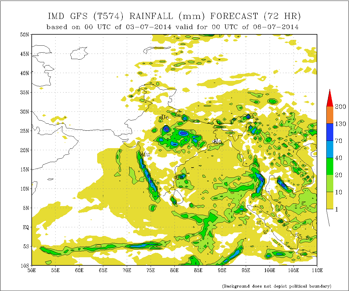
IMD GFS Rainfall Forecast Valid for oo UTC 6thJuly 2014 ( mainly 5th July)
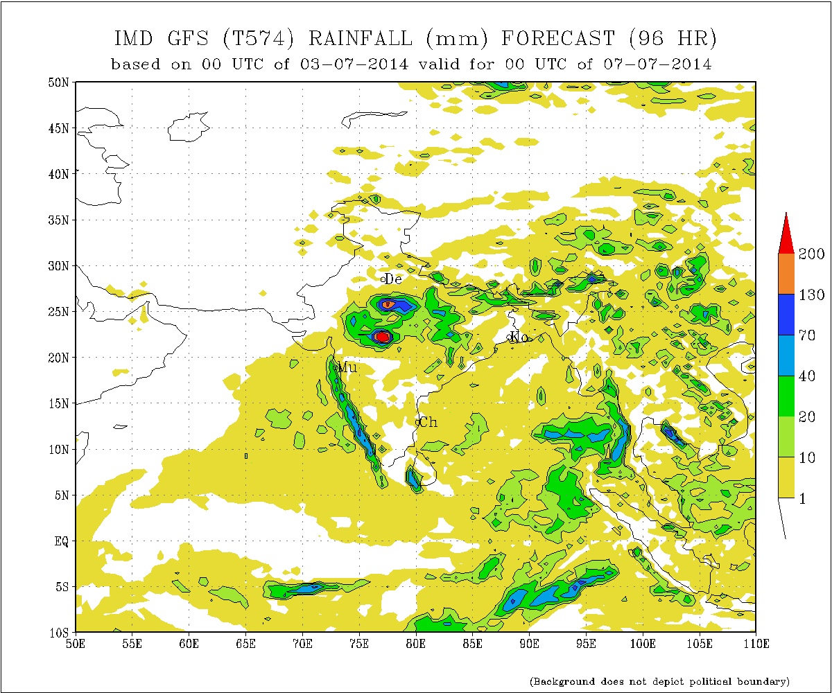
IMD GFS Rainfall Forecast Valid for oo UTC 7th July 2014 ( mainly 6th July)
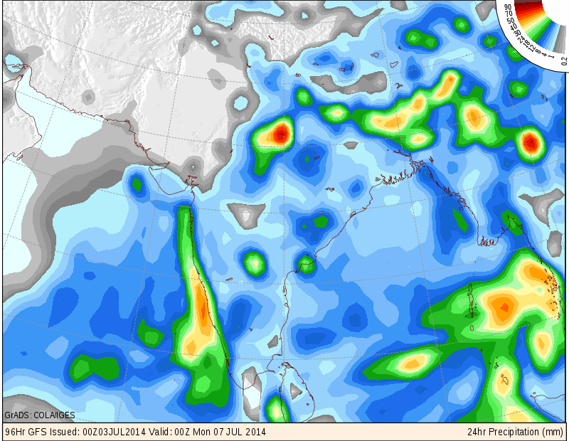
COLA/IGES Precipitation Forecast Map valid 00 UTC 7th July 2014
(mainly 6th July)
Weather Forecast In Akila Daily Dated 3rd July 2014