Current Weather Conditions on 1st July 2014 @ 3.00 pm.
The Cyclonic Circulation over coastal areas of Bangla Desh and neighborhood has descended to sea level and a Low Pressure area has formed over North Bay of Bengal and adjoining areas of Bangla Desh and Gangetic West Bengal. Associated cyclonic circulation extends upto 7.6 kms a.s.l tilting southwestwards with height.
The trough at mean sea level extends from Punjab to Eastcentral Bay of Bengal across Haryana, Uttar Pradesh, Jharkhand and the Center of the Low Pressure area and extends upto 1.5 kms above sea level.
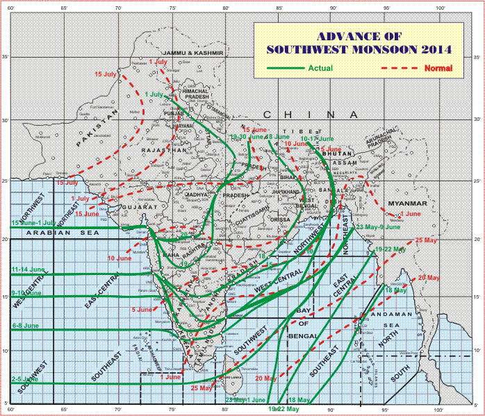
The Southwest Monsoon has further advanced into entire Uttarakhand,
Himachal Pradesh and Jammu & Kashmir, some more parts of Uttar Pradesh and some parts of Haryana and Punjab.
The Northern Limit of Monsoon (NLM) passes through Lat. 21°N / Long. 60°E, Lat.21°N / Long. 65°E, Veraval, Surat, Nashik, Washim, Damoh, Lucknow, Bareilly, Ambala and Amritsar.
Also conditions are favorable for further advance of Southwest Monsoon into some more parts of Madhya Pradesh, remaining parts of Uttar Pradesh, Haryana, Chandigarh & Delhi and Punjab and some parts of North Rajasthan during next 48 hours.
IMD Map Showing the Advance Of Southwest Monsoon Till 1st July 2014